'Celtic Fields' – Stiefkinder der
Archäologie Archaeology's stepchildren
Spuren urgeschichtlicher Beackerung in West-,
Mittel-, Ost- und Nordeuropa Traces of prehistoric farming in Western,
Central, Eastern and Northern Europe: Mertinger Forst-Grüner Sumpf-West, Bayern-Süd Bavaria-South
Weiter more...
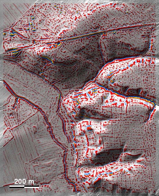
Westlich des "Grünen Sumpfs" im Mertinger Forst zeigen sich südlich einer gut
erkennbaren Römerstraße Fragmente von 'Celtic Fields' vor allem am Abhang zur
Niederung des Stadelbaches. Die Parzellengrenzen orientieren sich an den
Haupthimmelsrichtungen. To the west of the "Grüner Sumpf" in Mertinger Forst,
fragments of 'Celtic Fields' can be seen to the south of a clearly recognisable
Roman road, especially on the slope towards the lowland of the Stadelbach. The
boundaries of the plots are oriented towards the main cardinal directions. Weiter
more...
Daten © BVV/geodaten.bayern.de. Wenn Sie
diese Grafik herunterladen, müssen Sie zur Georeferenzierung mit Global Mapper
oder Mapinfo auch das
TAB-File laden
und stets im gleichen Verzeichnis speichern. (Rechte Maustaste; Ziel speichern
unter... Bei Umbenennung darauf achten, dass auch innerhalb des Tab-Files der
Dateiname entsprechend umbenannt wird!) Data © BVV/geodaten.bayern.de. If you
download this graphic, you must also load the
TAB-File for
georeferencing with Global Mapper or Mapinfo and save it always in the same
directory. (Right mouse button; save target as... When renaming, make sure that
the file name is also renamed within the tab file accordingly).
Grafik georeferenziert als
GEOTIFF
herunterladen z.B. für Avenza Maps + Smartphone oder als
KMZ-File für
Benutzung mit Locus Map + Smartphone oder Google Earth. Download
georeferenced graphics as
GEOTIFF
e.g. for Avenza Maps + Smartphone or as
KMZ-File for
use with Locus Map + Smartphone or Google Earth.
Zurück Back
Übersicht Bayern-Süd Overview Bavaria-South
Übersicht Bayern Overview Bavaria ©
Volker Arnold 2022