'Celtic Fields' – Stiefkinder der
Archäologie Archaeology's stepchildren
Spuren urgeschichtlicher Beackerung in West-,
Mittel-, Ost- und Nordeuropa Traces of prehistoric farming in Western,
Central, Eastern and Northern Europe: Rehling-Unterholz, Bayern-Süd Bavaria-South
Weiter more...
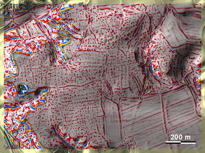
Im Unterholz, auf der Randhöhe des Lechtals südlich von Rehling (nördlich
Augsburg), finden sich auf sandig-lehmigen Böden schwach ausgeprägte,
möglicherweise sekundär unterteilte 'Celtic Fields'.
Zumindest die Ränder der übergeordneten Parzellen sind erkennbar. Zwei
Grabhügelgruppen, wovon die am Südrand der Grafik in die Hallstattzeit datiert.
Dort schließen auch latènezeitliche Siedlungsfunde an. In the Unterholz, on
the rim heights of the Lech valley south of Rehling (north of Augsburg), there
are weakly developed, possibly secondarily subdivided 'Celtic Fields' on
sandy-loamy soils. At least the edges of the superior plots are recognisable.
Two groups of barrows, of which those on the southern edge of the graphic date
to the Hallstatt period. Latène period settlement finds also adjoin there. Weiter
more...
Daten © BVV/geodaten.bayern.de. Wenn Sie
diese Grafik herunterladen, müssen Sie zur Georeferenzierung mit Global Mapper
oder Mapinfo auch das
TAB-File laden
und stets im gleichen Verzeichnis speichern. (Rechte Maustaste; Ziel speichern
unter... Bei Umbenennung darauf achten, dass auch innerhalb des Tab-Files der
Dateiname entsprechend umbenannt wird!) Data © BVV/geodaten.bayern.de. If you
download this graphic, you must also load the
TAB-File for
georeferencing with Global Mapper or Mapinfo and save it always in the same
directory. (Right mouse button; save target as... When renaming, make sure that
the file name is also renamed within the tab file accordingly).
Grafik georeferenziert als
GEOTIFF
herunterladen z.B. für Avenza Maps + Smartphone oder als
KMZ-File für
Benutzung mit Locus Map + Smartphone oder Google Earth. Download
georeferenced graphics as
GEOTIFF
e.g. for Avenza Maps + Smartphone or as
KMZ-File for
use with Locus Map + Smartphone or Google Earth.
Zurück Back
Übersicht Bayern-Süd Overview Bavaria-South
Übersicht Bayern Overview Bavaria ©
Volker Arnold 2023