Spuren urgeschichtlicher Beackerung in West-, Mittel-, Ost- und Nordeuropa Traces of prehistoric farming in Western, Central, Eastern and Northern Europe: Traubing-Südwest-Droßbergbuchet, Bayern-Süd Bavaria-South Weiter more...
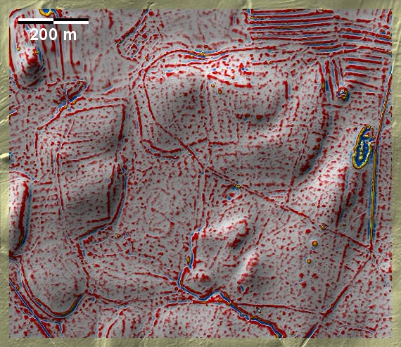
Im Waldbezirk Droßbergbuchet bei Traubing südwestlich von Starnberg finden sich Spuren von 'Celtic Fields' auf lehmig-kiesiger Jungmoräne. Mit ca. 720 m Meereshöhe sind die die höchstgelegenen bekannten ‚Celtic Fields‘ Deutschlands. Wie üblich in den stark reliefierten Jungmoränengebieten, sind die Parzellen eher unregelmäßig und an das Gelände angepasst. Trotzdem ist hier eine ungefähre Ausrichtung an die Haupthimmelsrichtungen feststellbar. Die Feldränder bilden an den Hängen Terrassenstufen und sind dort am besten erkennbar. Die kleine Grabhügelgruppe im Südosten der Grafik datiert in die Hallstattzeit. Die ziemlich isolierte Lage sowohl der Beackerungsspuren wie auch der nahen Grabhügelgruppe sprechen dafür, beide in einem, auch zeitlichen, Zusammenhang zu sehen. In the Droßbergbuchet forest district near Traubing, south-west of Starnberg, traces of 'Celtic Fields' can be found on loamy-gravelly young moraine. At around 720 m above sea level, these are the highest known 'Celtic Fields' in Germany. As usual in the strongly relieved young moraine areas, the plots are rather irregular and adapted to the terrain. Nevertheless, an approximate adaptation to the main cardinal directions can be detected here. The field margins form terrace steps on the slopes and are best recognisable there. The small group of tumuli in the south-east of the graphic dates to the Hallstatt period. The rather isolated location of both the tillage traces and the nearby group of tumuli suggest that both should be seen in a context, also in chronological terms. Weiter more...