'Celtic Fields' – Stiefkinder der
Archäologie Archaeology's stepchildren
Spuren urgeschichtlicher Beackerung in West-,
Mittel-, Ost- und Nordeuropa Traces of prehistoric farming in Western,
Central, Eastern and Northern Europe: Waidhofen-Eichberg-Nord, Bayern-Süd Bavaria-South
Weiter more...
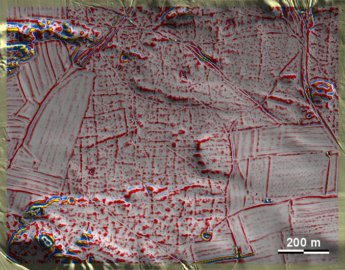
Im Norden des Eichbergs nördlich von Waidhofen an der Paar liegen auf Sandboden
Fragmente gut ausgeprägter 'Celtic Fields', die die Ränder übergeordneter
Parzellen sowie Spuren einer sekundären Unterteilung erkennen lassen, also dem
gekammerten Typ Przemęt zuzurechnen sind. Ihre Ausrichtung deckt sich etwa mit
den HaupthimmeIsrichtungen. Im westlich angrenzenden Wirtschaftsland sind alle
Spuren schlagartig beseitigt. In the north of the Eichberg north of Waidhofen
on the Paar, fragments of well-developed 'Celtic Fields' lie on sandy soil,
showing the edges of superior plots as well as traces of a secondary
subdivision, i.e. belonging to the chambered Przemęt type. Their alignment
roughly coincides with the main cardinal directions. In the adjoining farmland to
the west, all traces are abruptly eliminated. Weiter
more...
Daten © BVV/geodaten.bayern.de. Wenn Sie
diese Grafik herunterladen, müssen Sie zur Georeferenzierung mit Global Mapper
oder Mapinfo auch das
TAB-File laden
und stets im gleichen Verzeichnis speichern. (Rechte Maustaste; Ziel speichern
unter... Bei Umbenennung darauf achten, dass auch innerhalb des Tab-Files der
Dateiname entsprechend umbenannt wird!) Data © BVV/geodaten.bayern.de. If you
download this graphic, you must also load the
TAB-File for
georeferencing with Global Mapper or Mapinfo and save it always in the same
directory. (Right mouse button; save target as... When renaming, make sure that
the file name is also renamed within the tab file accordingly).
Grafik georeferenziert als
GEOTIFF
herunterladen z.B. für Avenza Maps + Smartphone oder als
KMZ-File für
Benutzung mit Locus Map + Smartphone oder Google Earth. Download
georeferenced graphics as
GEOTIFF
e.g. for Avenza Maps + Smartphone or as
KMZ-File for
use with Locus Map + Smartphone or Google Earth.
Zurück Back
Übersicht Bayern-Süd Overview Bavaria-South
Übersicht Bayern Overview Bavaria ©
Volker Arnold 2022