'Celtic Fields' – Stiefkinder der
Archäologie Archaeology's stepchildren
Spuren urgeschichtlicher Beackerung in West-,
Mittel-, Ost- und Nordeuropa Traces of prehistoric farming in Western,
Central, Eastern and Northern Europe: Gedsted-Sillehøje, Nordjütland
Weiter more...
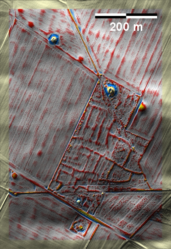
An den Sillehøje bei Gedsted südwestlich von Aars liegen in einer
Nadelholzanpflanzung gut ausgeprägte 'Celtic Fields' sowie einige erhaltene oder
überpflügte Grabhügel ringsum. Die meisten 'Celtic Fields' sind in einer
Tannenbaumkultur und deswegen in ihrem Fortbestand langfristig gefährdet. At
the Sillehøje near Gedsted, southwest of Aars, there are well-pronounced 'Celtic
Fields' in a coniferous plantation, as well as several preserved or overploughed
burial mounds all around. Most of the 'Celtic Fields' are cultivated with
Christmas trees and are therefore endangered in the long term. Weiter more...
Daten © sdfi.dk. Wenn Sie diese Grafik herunterladen, müssen Sie zur Georeferenzierung mit Global
Mapper oder Mapinfo auch das TAB-File
laden und stets im gleichen Verzeichnis speichern. (Rechte Maustaste; Ziel
speichern unter... Bei Umbenennung darauf achten,
dass auch innerhalb des Tab-Files der Dateiname entsprechend umbenannt wird!)
If you download this graphic, you must also load the TAB-File
for georeferencing with Global Mapper or Mapinfo and save it always in
the same directory. (Right mouse button; save target as... When renaming, make
sure that the file name is also renamed within the tab file accordingly).
Grafik georeferenziert als GEOTIFF herunterladen oder als
KMZ-File für Benutzung
mit Locus Map + Smartphone oder Google Earth. Download georeferenced graphics
as GEOTIFF e.g. for Avenza Maps + Smartphone or as
KMZ-File for use with Locus
Map + Smartphone or Google Earth.
Zurück
Back Übersicht Nordjütland Overview Jutland-North © Volker Arnold 2023