Spuren urgeschichtlicher Beackerung in West-, Mittel-, Ost- und Nordeuropa Traces of prehistoric farming in Western, Central, Eastern and Northern Europe: Nordjütland
'Celtic Fields' – Stiefkinder der
Archäologie Archaeology's stepchildren
Spuren urgeschichtlicher Beackerung in West-,
Mittel-, Ost- und Nordeuropa Traces of prehistoric farming in Western, Central,
Eastern and Northern Europe: Nordjütland
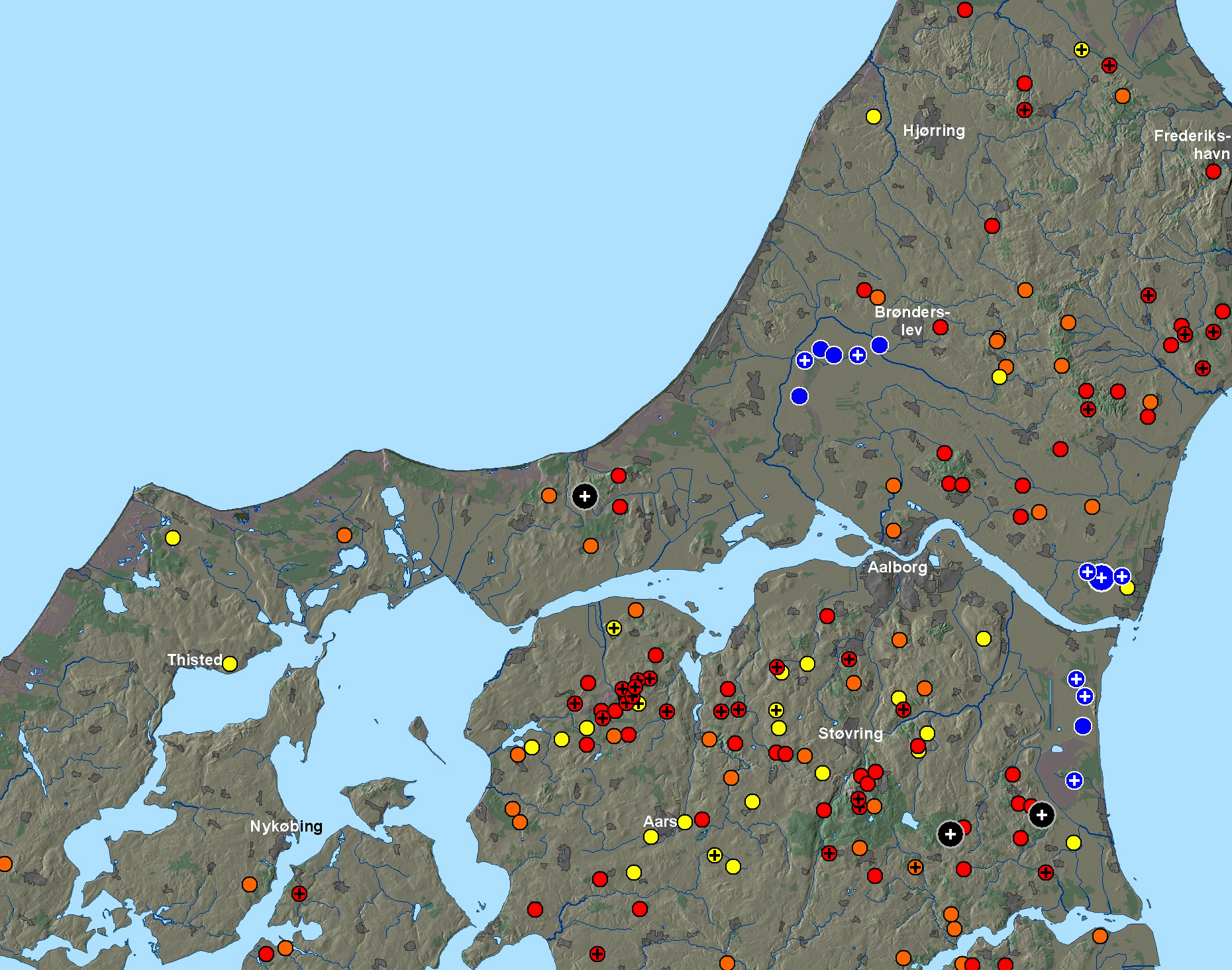
Celtic Fields in
Nordjütland nach LIDAR-Daten (schwarz: > 1 qkm, blau: unter Moor, gelb:
überpflügt, orange: unsichere Befunde). Bitte
klicken Sie auf die Kreuze für Details! Oder probieren Sie die Linkliste unten
bzw. einen "Rundgang"!
Celtic Fields in Northern Jutland according to LIDAR data (black: > 1 sq. km,
blue: beyond bog, yellow:
overploughed, orange: uncertain findings). Please click on the crosses for
details! Or try the link list below or a "tour"!
Zu den
Fundstellennamen On the site names
Wenn Sie diese Karte herunterladen, müssen Sie zur Georeferenzierung mit Global
Mapper oder Mapinfo auch das TAB-File laden
und stets im gleichen Verzeichnis speichern. (Rechte Maustaste; Ziel speichern
unter... Bei Umbenennung darauf achten, dass auch innerhalb des Tab-Files der
Dateiname entsprechend umbenannt wird!) Oder Sie laden die
Karte georeferenziert als GEOTIFF herunter.
If you download this graphic, you must also load the TAB-File
for georeferencing with Global Mapper or Mapinfo and save it always in
the same directory. (Right mouse button; save target as... When renaming, make
sure that the file name is also renamed within the tab file accordingly). Or you
can download the map georeferenced as GEOTIFF.
Albaek-Halden Skov
Arden Mølleskov
Byrsted Hede
Dronninglund-Storskov-NW
Eskær
Skov Gedsted-Sillehøje
Hals-Nørreskov
Hjortdal/Fosdal
Hørby-Kvistskov
Kølby-Skovbakke
Kongens
Tisted-Nord Lille Vildmose-Hostemark Skov
Lille Vildmose-Tofte Skov
Lille Vildmose-Voldbjerge-Ost
Lundby Hede Måstrup Hede-Nord
Nautrup-SW Nørre Vørså Hede
Ravnborg
Skov Rebild Bakker/Kyø Skov
Rønhøj Plant.-Süd
Rold-Fruelund
Sindal-Rævebakke Plant.
Skarpholt Plant.
Skørbæk Hede
Store
Vildmose-Grishøjgård Krat Store Vildmose-Ryssensgrav
Svenstrup-SW
Tisted-Nørskov/Mølleskov
Vegger
Plant.
Vindblæs-Süd Visborg-Eendelen
Vokslev-Stærhøje
Volsted Plant.
Die bei den Einzeldarstellungen ganz unten gezeigten
Google-Maps-Markierungen zeigen nicht immer genau die archäologischen Fundpunkte,
sondern jeweils den Mittelpunkt der Lasergrafik. The Google Maps markers
shown at the bottom of the individual web pages do not always show the exact
archaeological sites, but rather the centre of the laser graphic.
Zurück Back © Volker Arnold 2022