'Celtic Fields' – Stiefkinder der
Archäologie Archaeology's stepchildren
Spuren urgeschichtlicher Beackerung in West-,
Mittel-, Ost- und Nordeuropa Traces of prehistoric farming in Western,
Central, Eastern and Northern Europe: Ramten Skov, Ostjütland-Nord
Weiter more...
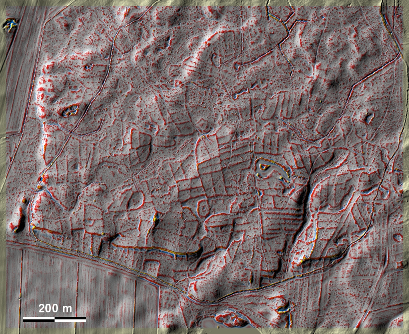
Im Ramten Skov zwischen Randers und Grenaa liegen überwiegend gut ausgeprägte
'Celtic Fields' sowie mindestens ein Grabhügel. Auffällig sind Gruppen sehr
schmaler Parzellen, die in einen Fall (südöstlich der Bildmitte, siehe Schnitt
NS) auch Wölbbeete sein könnten. Bemerkenswert ist auch die starke
Terrassenstufe am Südwestrand des Systems, wo die unteren Parzellen immerhin 15
% Gefälle aufweisen. In Ramten Skov between Randers and Grenaa there are
mostly well-developed 'Celtic Fields' and at least one burial mound. Groups of
very narrow plots are conspicuous, which in one case (south-east of the centre
of the picture, see section NS) could also be ridge-and-furrow beds. Also
noteworthy is the strong terracing on the south-western edge of the system,
where the lower plots still have a 15% slope.
Weiter more...
|
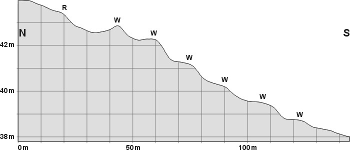
Schnitt NS durch mehrere mögliche
Wölbbeete (W). R: normaler Parzellenrand
Section NS through several possible ridge-and-furrow beds (W). R:
normal plot edge |
|
|
 |
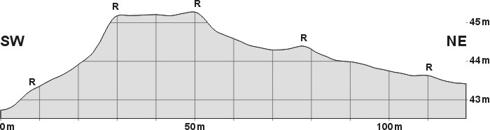
Oben: Schnitt SW-NE durch
mehrere Parzellen, 10-fach überhöht. R: Raine
Top: Section SW-NE through several plots, 10 times superelevated.
R: Plot rims
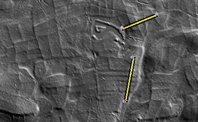
Links: Lage der Schnitte
Left: Position of the sections
|
Daten © sdfi.dk. Wenn Sie diese Grafik herunterladen, müssen Sie zur Georeferenzierung mit Global
Mapper oder Mapinfo auch das TAB-File
laden und stets im gleichen Verzeichnis speichern. (Rechte Maustaste; Ziel
speichern unter... Bei Umbenennung darauf achten,
dass auch innerhalb des Tab-Files der Dateiname entsprechend umbenannt wird!)
If you download this graphic, you must also load the TAB-File
for georeferencing with Global Mapper or Mapinfo and save it always in
the same directory. (Right mouse button; save target as... When renaming, make
sure that the file name is also renamed within the tab file accordingly).
Grafik georeferenziert als GEOTIFF herunterladen oder als
KMZ-File für Benutzung
mit Locus Map + Smartphone oder Google Earth. Download georeferenced graphics
as GEOTIFF e.g. for Avenza Maps + Smartphone or as
KMZ-File for use with Locus
Map + Smartphone or Google Earth.
Zurück
Back Übersicht Ostjütland-Nord
Overview Eastern Jutland-North © Volker Arnold 2022