'Celtic Fields' – Stiefkinder der
Archäologie Archaeology's stepchildren
Spuren urgeschichtlicher Beackerung in West-,
Mittel-, Ost- und Nordeuropa Traces of prehistoric farming in Western,
Central, Eastern and Northern Europe: Sem-Myrhøj, Ostjütland-Nord
Weiter more...
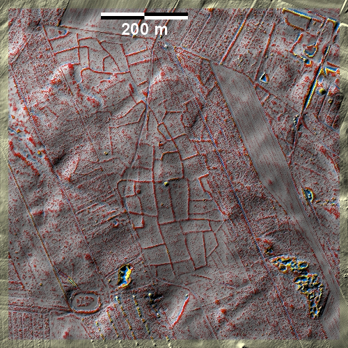
In dem Heiderest Myrhøj bei Sem östlich von Mariager gibt es neben zwei
Grabhügeln gut ausgeprägte 'Celtic Fields', während ihre Spuren in den
angrenzenden Aufforstungen schlecht erhalten bzw. nicht (mehr?) vorhanden sind.
In the heath remnant Myrhøj near Sem east of Mariager, there are well-developed
'Celtic Fields' in addition to two burial mounds, while their traces are poorly
preserved or not (any longer?) present in the adjacent afforestations.
Weiter more...
 |
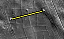 |
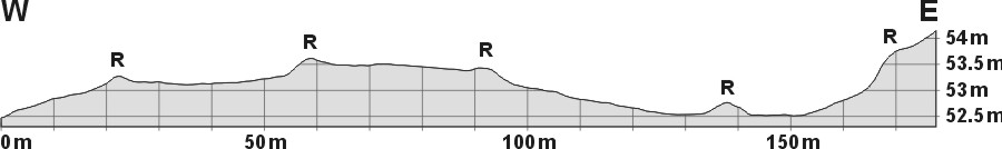
| Schnitt W-E durch
vier Parzellen Section W-E through four plots |
Lage des Schnittes Position
of section |
Daten © sdfi.dk. Wenn Sie diese Grafik herunterladen, müssen Sie zur Georeferenzierung mit Global
Mapper oder Mapinfo auch das TAB-File
laden und stets im gleichen Verzeichnis speichern. (Rechte Maustaste; Ziel
speichern unter... Bei Umbenennung darauf achten,
dass auch innerhalb des Tab-Files der Dateiname entsprechend umbenannt wird!)
If you download this graphic, you must also load the TAB-File
for georeferencing with Global Mapper or Mapinfo and save it always in
the same directory. (Right mouse button; save target as... When renaming, make
sure that the file name is also renamed within the tab file accordingly).
Grafik georeferenziert als GEOTIFF herunterladen oder als
KMZ-File für Benutzung
mit Locus Map + Smartphone oder Google Earth. Download georeferenced graphics
as GEOTIFF e.g. for Avenza Maps + Smartphone or as
KMZ-File for use with Locus
Map + Smartphone or Google Earth.
Zurück
Back Übersicht Ostjütland-Nord
Overview Eastern Jutland-North © Volker Arnold 2022