'Celtic Fields' – Stiefkinder der
Archäologie Archaeology's stepchildren
Spuren urgeschichtlicher Beackerung in West-,
Mittel-, Ost- und Nordeuropa Traces of prehistoric farming in Western,
Central, Eastern and Northern Europe: Viborg-Hedeplantage-Røverhøje, Ostjütland-Nord
Weiter more...
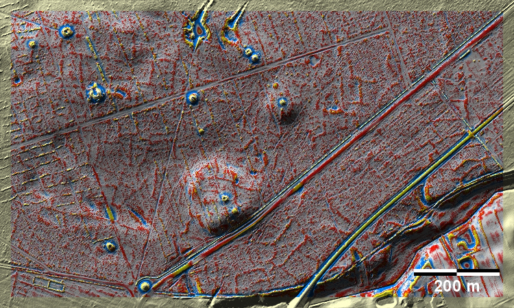
Die Hedeplantage bei den Røverhøje südlich von Viborg ist eine Aufforstung einer
ehemaligen Heidefläche. Hier haben sich die vorher sicher deutlicheren Spuren
von 'Celtic Fields' nur sehr schwach erhalten, im Gegensatz zu den Grabhügeln.
The Hede plantation around the Røverhøje south of Viborg is a reforestation
of a former heath area. Here the traces of 'Celtic Fields', which were certainly
clearer before, have survived only very faintly, in contrast to the burial
mounds.
Weiter more...
Daten © sdfi.dk. Wenn Sie diese Grafik herunterladen, müssen Sie zur Georeferenzierung mit Global
Mapper oder Mapinfo auch das TAB-File
laden und stets im gleichen Verzeichnis speichern. (Rechte Maustaste; Ziel
speichern unter... Bei Umbenennung darauf achten,
dass auch innerhalb des Tab-Files der Dateiname entsprechend umbenannt wird!)
If you download this graphic, you must also load the TAB-File
for georeferencing with Global Mapper or Mapinfo and save it always in
the same directory. (Right mouse button; save target as... When renaming, make
sure that the file name is also renamed within the tab file accordingly).
Grafik georeferenziert als GEOTIFF herunterladen oder als
KMZ-File für Benutzung
mit Locus Map + Smartphone oder Google Earth. Download georeferenced graphics
as GEOTIFF e.g. for Avenza Maps + Smartphone or as
KMZ-File for use with Locus
Map + Smartphone or Google Earth.
Zurück
Back Übersicht Ostjütland-Nord
Overview Eastern Jutland-North © Volker Arnold 2023