'Celtic Fields' – Stiefkinder der
Archäologie Archaeology's stepchildren
Spuren urgeschichtlicher Beackerung in West-,
Mittel-, Ost- und Nordeuropa Traces of prehistoric farming in Western,
Central, Eastern and Northern Europe: Viborg-Neckelmanns Plant., Ostjütland-Nord
Weiter more...
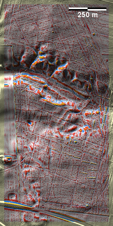
In Neckelmanns Plantage, einer Heideaufforstung am nördlichen Ortsrand von
Viborg, haben nur wenige schwache Spuren von 'Celtic Fields' westlich der
Bildmitte und mindestens ein
Grabhügel die Forstmaßnahmen überstanden. Am Ostrand ein Altwegfächer. In
Neckelmanns Plantage, a heath afforestation on the northern outskirts of Viborg,
only a few faint traces of 'Celtic Fields' west of the centre of the image and at least one burial mound have
survived the forestry measures. On the eastern edge an ancient trail fan.
Weiter more...
Daten © sdfi.dk. Wenn Sie diese Grafik herunterladen, müssen Sie zur Georeferenzierung mit Global
Mapper oder Mapinfo auch das TAB-File
laden und stets im gleichen Verzeichnis speichern. (Rechte Maustaste; Ziel
speichern unter... Bei Umbenennung darauf achten,
dass auch innerhalb des Tab-Files der Dateiname entsprechend umbenannt wird!)
If you download this graphic, you must also load the TAB-File
for georeferencing with Global Mapper or Mapinfo and save it always in
the same directory. (Right mouse button; save target as... When renaming, make
sure that the file name is also renamed within the tab file accordingly).
Grafik georeferenziert als GEOTIFF herunterladen oder als
KMZ-File für Benutzung
mit Locus Map + Smartphone oder Google Earth. Download georeferenced graphics
as GEOTIFF e.g. for Avenza Maps + Smartphone or as
KMZ-File for use with Locus
Map + Smartphone or Google Earth.
Zurück
Back Übersicht Ostjütland-Nord
Overview Eastern Jutland-North © Volker Arnold 2023