'Celtic Fields' – Stiefkinder der
Archäologie Archaeology's stepchildren
Spuren urgeschichtlicher Beackerung in West-,
Mittel-, Ost- und Nordeuropa Traces of prehistoric farming in Western,
Central, Eastern and Northern Europe: Brædstrup-Ring Skov, Ostjütland-Süd
Weiter more...
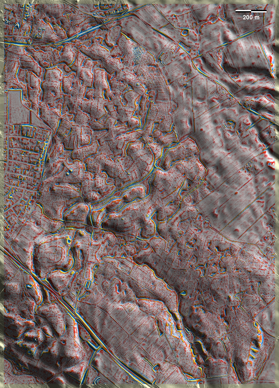
Der Ring Skov bei Brædstrup nordwestlich von Horsens liegt in einer kuppigen
Jungmoränenlandschaft mit vielen abflusslosen Senken. Große Teile sind mit mehr
oder weniger gut ausgeprägten 'Celtic Fields' bedeckt. Im Südwesten der Grafik
fällt ein fast ringförmiger Parzellenrand auf einer Kuppe auf, der Spuren
weiterer Unterteilung aufweist. Außerdem gibt es mehrere Grabhügel. Ring Skov
near Brædstrup northwest of Horsens is situated in a hilly young moraine
landscape with many drainless depressions. Large parts are covered with more or
less well-developed 'Celtic Fields'. In the southwest of the graphic, an almost
ring-shaped plot edge on a knoll stands out, showing traces of further
subdivision. There are also several burial mounds. Weiter more...
Daten © sdfi.dk. Wenn Sie diese Grafik herunterladen, müssen Sie zur Georeferenzierung mit Global
Mapper oder Mapinfo auch das TAB-File
laden und stets im gleichen Verzeichnis speichern. (Rechte Maustaste; Ziel
speichern unter... Bei Umbenennung darauf achten,
dass auch innerhalb des Tab-Files der Dateiname entsprechend umbenannt wird!)
If you download this graphic, you must also load the TAB-File
for georeferencing with Global Mapper or Mapinfo and save it always in
the same directory. (Right mouse button; save target as... When renaming, make
sure that the file name is also renamed within the tab file accordingly).
Grafik georeferenziert als GEOTIFF herunterladen oder als
KMZ-File für Benutzung
mit Locus Map + Smartphone oder Google Earth. Download georeferenced graphics
as GEOTIFF e.g. for Avenza Maps + Smartphone or as
KMZ-File for use with Locus
Map + Smartphone or Google Earth.
Zurück
Back Übersicht Ostjütland-Süd
Overview Eastern Jutland-South © Volker Arnold 2022