Spuren urgeschichtlicher Beackerung in West-, Mittel-, Ost- und Nordeuropa Traces of prehistoric farming in Western, Central, Eastern and Northern Europe: Pionki-SW, Ost-Polen Weiter more...
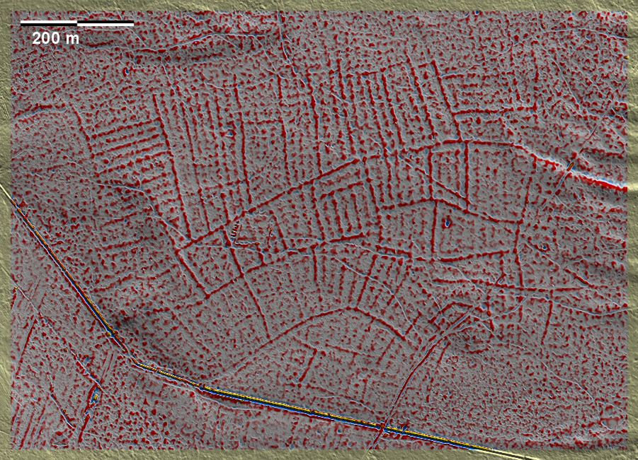
Südwestlich von Pionki liegen in einem ausgedehnten Wald völlig isoliert diese 'Celtic Fields'. Das System erscheint vollständig, umfasst ca. 55 ha und scheint sich von Süden nach Norden entwickelt zu haben. Am Südostrand des Systems liegt eine Parzelle, die nicht zu den übrigen passt: ein "Kernelement", wo vielleicht die Ansiedlung lag. Die übergeordneten Parzellen sind sehr deutlich in schmale Streifen unterteilt und deswegen nicht immer klar bestimmbar. Ca. 4 km nordöstlich liegen im gleichen Waldgebiet zwei isolierte, ähnlich strukturierte, aber kleinere 'Celtic Fields', die als Ausbauten angesehen werden können (Pionki-West). Southwest of Pionki, these 'Celtic Fields' are completely isolated in an extensive forest. The system appears complete, covering about 55 ha, and seems to have developed from south to north. On the south-eastern edge of the system lies a parcel that does not fit in with the others: a 'core element' where perhaps the settlement was located. The overlying parcels are very clearly divided into narrow strips and therefore not always clearly determinable. Approximately 4 km to the north-east, in the same wooded area, there are two isolated, similarly structured but smaller 'Celtic Fields', which can be regarded as extensions. (Pionki-West). Weiter more...