'Celtic Fields' – Stiefkinder der
ArchäologieArchaeology's stepchildren
Spuren urgeschichtlicher Beackerung in West-,
Mittel- und Nordeuropa Traces of prehistoric farming in Western,
Central, Eastern and Northern Europe: Fovslet Skov, Süd-Jütland
Weiter more...
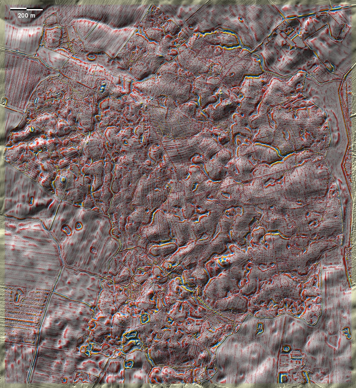
Im Fovslet Skov südwestlich von Kolding sind in einer kuppigen
Jungmoränenlandschaft nur wenige, schwach ausgeprägte 'Celtic-Fields'-Raine
auszumachen. Allerdings wirkt die Landschaft besonders im Nordosten der Grafik
"flachgebügelt": Ergebnis früherer Beackerung ohne Ausprägung von erhöhten
Feldrainen? In Norden und Nordwesten einige größere Grabhügel. In
Fovslet Skov, southwest of Kolding, only a few weakly developed 'Celtic Fields'
can be discerned in a dome-shaped young moraine landscape. However, the
landscape, especially in the north-east of the graphic, appears 'flat-ironed':
the result of earlier cultivation without the development of raised field
margins? Some larger barrows in the north and north-west.
Weiter more...
Daten © sdfi.dk. Wenn Sie diese Grafik herunterladen, müssen Sie zur Georeferenzierung mit Global
Mapper oder Mapinfo auch das TAB-File
laden und stets im gleichen Verzeichnis speichern. (Rechte Maustaste; Ziel
speichern unter... Bei Umbenennung darauf achten,
dass auch innerhalb des Tab-Files der Dateiname entsprechend umbenannt wird!)
If you download this graphic, you must also load the TAB-File
for georeferencing with Global Mapper or Mapinfo and save it always in
the same directory. (Right mouse button; save target as... When renaming, make
sure that the file name is also renamed within the tab file accordingly).
Grafik georeferenziert als GEOTIFF herunterladen oder als
KMZ-File für Benutzung
mit Locus Map + Smartphone oder Google Earth. Download georeferenced graphics
as GEOTIFF e.g. for Avenza Maps + Smartphone or as
KMZ-File for use with Locus
Map + Smartphone or Google Earth.
Zurück
Back Übersicht Südjütland Overview
South Jutland © Volker Arnold 2022