'Celtic Fields' – Stiefkinder der
Archäologie Archaeology's stepchildren
Spuren urgeschichtlicher Beackerung in West-,
Mittel-, Ost- und Nordeuropa Traces of prehistoric farming in Western,
Central, Eastern and Northern Europe: Vind-Løvhøje, West-Jütland
Weiter more...
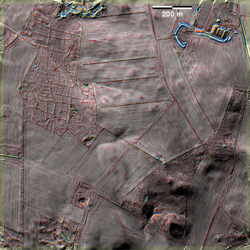
In den Løvhøje bei Vind südlich von Holstebro liegen auf Altmoräne mäßig
ausgeprägte 'Celtic Fields' teils in Heide, teils in Laubwald im Nordwesten der
Grafik. Im Südosten gibt es schwächer ausgeprägte Reste (und einen Grabhügel)
nur im aufgeforsteten Nordzipfel. In the Løvhøje near Vind south of
Holstebro, moderately pronounced 'Celtic Fields' lie on old moraine partly in
heath, partly in deciduous forest in the northwest of the graphic. To the
southeast, there are weaker remnants (and a burial mound) only in the afforested
northern tip.
Weiter more...
Daten © sdfi.dk. Wenn Sie diese Grafik herunterladen, müssen Sie zur Georeferenzierung mit Global
Mapper oder Mapinfo auch das TAB-File
laden und stets im gleichen Verzeichnis speichern. (Rechte Maustaste; Ziel
speichern unter... Bei Umbenennung darauf achten,
dass auch innerhalb des Tab-Files der Dateiname entsprechend umbenannt wird!)
If you download this graphic, you must also load the TAB-File
for georeferencing with Global Mapper or Mapinfo and save it always in
the same directory. (Right mouse button; save target as... When renaming, make
sure that the file name is also renamed within the tab file accordingly).
Grafik georeferenziert als GEOTIFF herunterladen oder als
KMZ-File für Benutzung
mit Locus Map + Smartphone oder Google Earth. Download georeferenced graphics
as GEOTIFF e.g. for Avenza Maps + Smartphone or as
KMZ-File for use with Locus
Map + Smartphone or Google Earth.
Zurück
Back Übersicht Westjütland Overview
Jutland-West © Volker Arnold 2023