 |
 |
'Celtic Fields' – Archaeology's
stepchildren
Traces of prehistoric farming in Western,
Central, Eastern and Northern Europe
Website under construction, ready in German language:
Schleswig-Holstein and (partly without texts) Denmark, New
in German/English: Poland
Bavaria Hesse
Netherlands/Flanders
Northrhine-Wesphalia
Brandenburg
Saxonia-Anhalt
This website is optimised for desktops and laptops, not for tablets and smartphones (if, use landscape format)! However, data download should work on any media.)
Surface LIDAR data, more and more publicly available, cover increasing areas in a sufficient quality. They lead to knowledge of numerous prehistoric 'Celtic Fields' in northern, middle and eastern Europe: small more or less rectangular close-packed field parcels forming coherent systems, which are still recognizable on favourable terms. They can be recognised by their boundaries: slight ramparts or, on slopes, terraces. Meanwhile more than 1000 systems are registrated only in Schleswig-Holstein and Denmark, mainly in ancient forests, but also in actual and forested heathland. More than 50 systems cover more than one square kilometer: distinctive territories, whose outer borders were subject of dynamics and remain thus vague. Where they occur, they are by far the largest prehistoric ground monuments! Otherwise system sizes are found sometimes which may be cultivated by only one single farm. Intensive searches where laser data were available or accessible led to the discovery of 'Celtic Fields' in Mecklenburg-Western Pomerania, Brandenburg, Saxony-Anhalt, Hesse and Bavaria, as well as in the Czech Republic and above all in Poland, where the largest contiguous areas north of Białystok are located (approx. 20 square kilometres). But also east of Hamburg and Rostock as well as south of Munich and Frankfurt huge areas with 'Celtic Fields' have been discovered. On Terminology
|
|
|
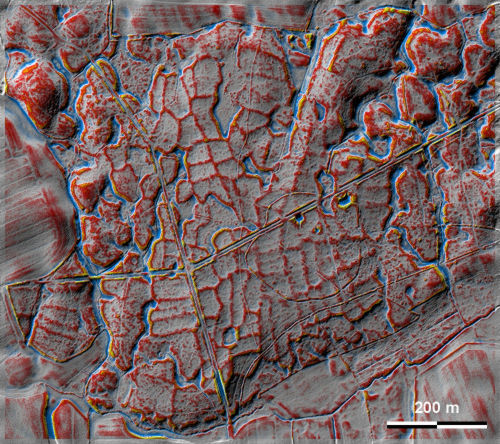
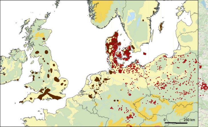
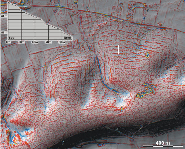
'Celtic Fields' in the Außelbek forest at Ülsby, Anglia, Schleswig-Holstein. Data © LVermGeo SH / 'Celtic Fields' in Europe (Map Arnoldussen 2018, red dots supplemented Arnold/Banasiak/Berezowski)
Prevailing on sandy soils at least parts of the parcel borders seem to be created in form of narrow embankments. Obviously long-time ploughing and cultivating lead to increasing raising and widening of the parcel borders of its own volition, combined with an increasingly through-like form of the parcels. An investigation of a faintly pronounced parcel border in the Riesewohld forest, Dithmarschen, came to a cultivation span of ca. 600 years during late Bronze and Preroman Iron Age. Dates from other systems resulted in similar or even longer time spans. Regularly traces of manuring are found in the ploughed soil of the parcel borders in the form of intensily broken house litter.
 |
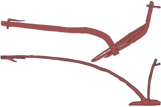 |
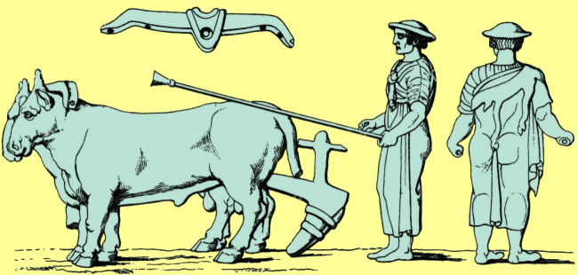
'Ploughman of Arezzo', etruscan bronze figurine, mid of the first millenium BC (left, wood engraving, 19th c.) – Ard types from danish bogs in Himmerland (right, above Døstrup, below Vebbestrup) after Viggo Nielsen / Glob
The wide layout diversity of the systems is mainly dependent on soil type and relief. Thus there are main differences in older and younger moraine areas, in lowland and hilly country. In the north, an overall development becomes apparent from more or less quadratic parcels to narrow oblonge-sized ones. While the former were ploughed crossswise with ards (hoog ploughs) as proved accasionally, extremely long and small parcels may be cultivated bidirectional possibly by a mouldboard plough. Small ridge-and-furrow systems were created respecting the old Celtic Field parcel borders in some Danish systems, which may indicate a partial continuity over the "dark ages" after the migration period. In parts of central Germany, Bavaria and Hesse, and especially in Poland (except its north-east), there is often a type with very large superior plots, which are (secondarily?) divided into subordinate smaller plots.
At slopes, the ridges between the
parcels convert to pronounced terrain steps (lynchets). Ostenberg, Stemweder
Berge, northeastern Westfalia (with slice). Data: Land NRW 2017
It remains still vague which and to what extent parcels lay fallow or were used
as pastures. Anyway, the forming of the parcels may be much more a result of
soil cultivation than of grazing. A further scope of duty is the dating of the
systems and their usage periods. Certainly insufficent first dates cannot
exclude that Celtic Fields may origin during the early Nordic Bronze Age, though
the known buildings show still no evidence of stables. Definitely they are
present since the younger Nordic Bronze Age around 1000 BC, together with the beginnings of
indoor housing of animals in the north and west, which could be iniciated by
climatic decreases and is
evident by changed house layouts. Contemporarily a stationary agriculture was
possible over centuries which may have replaced prevailing migrating
cultivation. Animal housing leads to an accumulation of manure, bedding and
litter which was spread at the parcels for fertilisation, together with soil
material prevailing from wet grounds. All this represents a coequal change to
the agraric "revolution" at the beginning of the neolithic.
Whether this also applies to the systems south of the mid-mountain areas and in
Poland should be researched.