'Celtic Fields' – Stiefkinder der
Archäologie Archaeology's stepchildren
Spuren urgeschichtlicher Beackerung in West-,
Mittel-, Ost- und Nordeuropa Traces of prehistoric farming in Western,
Central, Eastern and Northern Europe: Vinkel-Randrup Skov, Ostjütland-Nord
Weiter more...
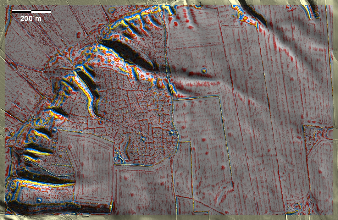
Im Randrup Skov bei Vinkel südöstlich von Viborg liegen 'Celtic Fields' in
mäßiger Ausprägung auf einer Hochfläche über der Nørreå, außerdem einige
Grabhügel. Zahlreiche überpflügte Grabhügel und schwache Spuren im heutigen
Ackerland deuten darauf, dass die damals bewirtschaftete Fläche früher erheblich
größer war. In Randrup Skov near Vinkel, southeast of Viborg, 'Celtic Fields'
lie in moderate pronouncement on a plateau above the Nørreå, as well as several
burial mounds. Numerous overploughed burial mounds and faint traces in today's
farmland indicate that the area cultivated at that time was once considerably
larger.
Weiter more...
Daten © sdfi.dk. Wenn Sie diese Grafik herunterladen, müssen Sie zur Georeferenzierung mit Global
Mapper oder Mapinfo auch das TAB-File
laden und stets im gleichen Verzeichnis speichern. (Rechte Maustaste; Ziel
speichern unter... Bei Umbenennung darauf achten,
dass auch innerhalb des Tab-Files der Dateiname entsprechend umbenannt wird!)
If you download this graphic, you must also load the TAB-File
for georeferencing with Global Mapper or Mapinfo and save it always in
the same directory. (Right mouse button; save target as... When renaming, make
sure that the file name is also renamed within the tab file accordingly).
Grafik georeferenziert als GEOTIFF herunterladen oder als
KMZ-File für Benutzung
mit Locus Map + Smartphone oder Google Earth. Download georeferenced graphics
as GEOTIFF e.g. for Avenza Maps + Smartphone or as
KMZ-File for use with Locus
Map + Smartphone or Google Earth.
Zurück
Back Übersicht Ostjütland-Nord
Overview Eastern Jutland-North © Volker Arnold 2023