Spuren urgeschichtlicher Beackerung in West-, Mittel-, Ost- und Nordeuropa Traces of prehistoric farming in Western, Central, Eastern and Northern Europe: Forlev-Findelen, Ostjütland-Süd Weiter more...
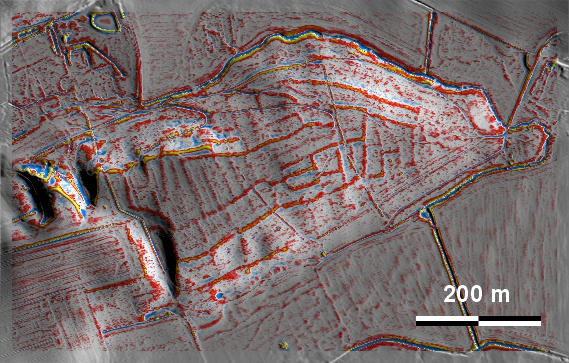
In dem Wäldchen Findelen bei Forlev am nordwestlichen Ortsrand von Skanderborg liegen gut ausgeprägte 'Celtic Fields' auf einem markanten und gut abriegelbaren Geländevorsprung über einer Niederung. Sollte sich das bewirtschaftete Areal nicht noch weiter nach Westen erstreckt haben, hätte es ca. 12 ha umfasst – genug für die Versorgung von einer bis zwei Hofstellen. Ca. 1.5 km westlich befindet sich der Ilsø, dessen pollenanalytische Untersuchung eine starke Auflichtungsphase in der Mitte und der zweiten Hälfte des 1. Jahrtausends BC ergab, was als Datierungsindiz für die 'Celtic Fields' gelten kann. In the small wood of Findelen near Forlev on the north-western outskirts of Skanderborg, well-developed 'Celtic Fields' lie on a prominent and well-closable promontory above a lowland. If the cultivated area had not extended further west, it would have covered about 12 ha – enough to supply one or two farmsteads. About 1.5 km to the west lies the Ilsø, whose pollen analysis revealed a strong clearing phase in the middle and second half of the 1st millennium BC, which can be regarded as a dating indication for the 'Celtic Fields'. Weiter more...