'Celtic Fields' – Stiefkinder der
Archäologie Archaeology's stepchildren
Spuren urgeschichtlicher Beackerung in West-,
Mittel- und Nordeuropa Traces of prehistoric farming in Western,
Central, Eastern and Northern Europe: Ødis-Drenderup Skov, Süd-Jütland
Weiter more...
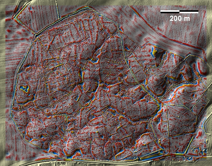
Im Drenderup Skov bei Ødis südwestlich von Kolding findet man teilweise schwach
ausgeprägte Spuren von 'Celtic Fields', die überwiegend zu langgestreckten
Parzellen zu gehören scheinen. In Drenderup Skov near Ødis, southwest of
Kolding, there are partly faintly pronounced traces of 'Celtic Fields', most of
which seem to belong to elongated plots.
Weiter more...
Daten © sdfi.dk. Wenn Sie diese Grafik herunterladen, müssen Sie zur Georeferenzierung mit Global
Mapper oder Mapinfo auch das TAB-File
laden und stets im gleichen Verzeichnis speichern. (Rechte Maustaste; Ziel
speichern unter... Bei Umbenennung darauf achten,
dass auch innerhalb des Tab-Files der Dateiname entsprechend umbenannt wird!)
If you download this graphic, you must also load the TAB-File
for georeferencing with Global Mapper or Mapinfo and save it always in
the same directory. (Right mouse button; save target as... When renaming, make
sure that the file name is also renamed within the tab file accordingly).
Grafik georeferenziert als GEOTIFF herunterladen oder als
KMZ-File für Benutzung
mit Locus Map + Smartphone oder Google Earth. Download georeferenced graphics
as GEOTIFF e.g. for Avenza Maps + Smartphone or as
KMZ-File for use with Locus
Map + Smartphone or Google Earth.
Zurück
Back Übersicht Südjütland Overview
South Jutland © Volker Arnold 2022