'Celtic Fields' – Stiefkinder der
Archäologie Archaeology's stepchildren
Spuren urgeschichtlicher Beackerung in West-,
Mittel-, Ost- und Nordeuropa Traces of prehistoric farming in Western,
Central, Eastern and Northern Europe: Kronhede Plantage-SW, West-Jütland
Weiter more...
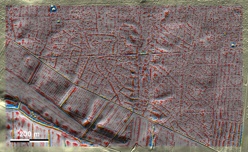
Am Südwestrand der Kronhede Plantage nordwestlich von Holstebro liegen mäßig
ausgeprägte 'Celtic Fields' sowie wenige Grabhügel. Soweit man die schwachen
Spuren beurteilen kann, hat man den Eindruck, dass sich hier zwei verschieden
ausgerichtete Systeme überlagern. On the south-western edge of Kronhede
Plantation north-west of Holstebro are moderately pronounced 'Celtic Fields' and
a few burial mounds. As far as one can judge from the faint traces, one has the
impression that two differently oriented systems overlap here.
Weiter more...
Daten © sdfi.dk. Wenn Sie diese Grafik herunterladen, müssen Sie zur Georeferenzierung mit Global
Mapper oder Mapinfo auch das TAB-File
laden und stets im gleichen Verzeichnis speichern. (Rechte Maustaste; Ziel
speichern unter... Bei Umbenennung darauf achten,
dass auch innerhalb des Tab-Files der Dateiname entsprechend umbenannt wird!)
If you download this graphic, you must also load the TAB-File
for georeferencing with Global Mapper or Mapinfo and save it always in
the same directory. (Right mouse button; save target as... When renaming, make
sure that the file name is also renamed within the tab file accordingly).
Grafik georeferenziert als GEOTIFF herunterladen oder als
KMZ-File für Benutzung
mit Locus Map + Smartphone oder Google Earth. Download georeferenced graphics
as GEOTIFF e.g. for Avenza Maps + Smartphone or as
KMZ-File for use with Locus
Map + Smartphone or Google Earth.
Zurück
Back Übersicht Westjütland Overview
Jutland-West © Volker Arnold 2023