'Celtic Fields' – Stiefkinder der
Archäologie Archaeology's stepchildren
Spuren urgeschichtlicher Beackerung in West-,
Mittel-, Ost- und Nordeuropa Traces of prehistoric farming in Western,
Central, Eastern and Northern Europe: Gerolfing-Geißstall, Bayern-West Bavaria-West
Weiter more...
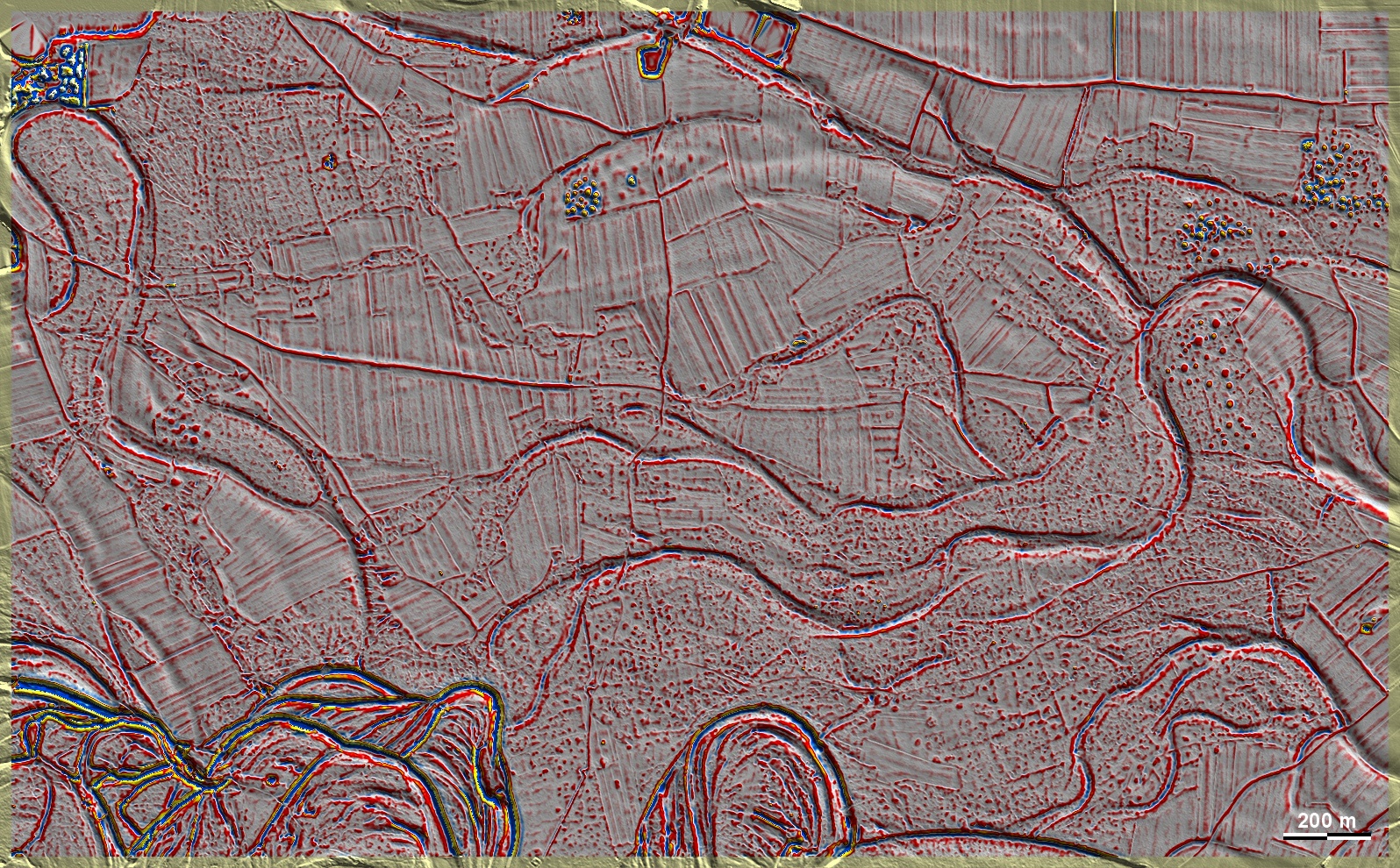
In den Waldstücken Geißstall, Stocket und Ring westlich von Ingolstadt-Gerolfing
liegen auf Donauschottern schwach ausgeprägte und fragmentierte 'Celtic Fields',
deren Ausrichtung von den Haupthimmelsrichtungen etwas nach Westen abweicht. Sie
sind umgeben von mehreren größeren Grabhügelgruppen, von denen die am Nordrand
der Grafik (über der Bildmitte) Betattungen der Bronze-, Hallstatt- und
Latènezeit aufwies. In the wooded areas of Geißstall, Stocket and Ring, west
of Ingolstadt-Gerolfing, there are weakly developed and fragmented 'Celtic
Fields' on Danube gravels, whose orientation deviates somewhat from the main
cardinal directions to the west. They are surrounded by several larger groups of
barrows, of which the one at the northern edge of the graphic (above the centre
of the picture) had burials of the Bronze, Hallstatt and Latène periods. Weiter
more...
Daten © BVV/geodaten.bayern.de. Wenn Sie
diese Grafik herunterladen, müssen Sie zur Georeferenzierung mit Global Mapper
oder Mapinfo auch das
TAB-File laden
und stets im gleichen Verzeichnis speichern. (Rechte Maustaste; Ziel speichern
unter... Bei Umbenennung darauf achten, dass auch innerhalb des Tab-Files der
Dateiname entsprechend umbenannt wird!) Data © BVV/geodaten.bayern.de. If you
download this graphic, you must also load the
TAB-File for
georeferencing with Global Mapper or Mapinfo and save it always in the same
directory. (Right mouse button; save target as... When renaming, make sure that
the file name is also renamed within the tab file accordingly).
Grafik georeferenziert als
GEOTIFF
herunterladen z.B. für Avenza Maps + Smartphone oder als
KMZ-File für
Benutzung mit Locus Map + Smartphone oder Google Earth. Download
georeferenced graphics as
GEOTIFF
e.g. for Avenza Maps + Smartphone or as
KMZ-File for
use with Locus Map + Smartphone or Google Earth.
Zurück Back
Übersicht Bayern-West Overview Bavaria-West
Übersicht Bayern Overview Bavaria ©
Volker Arnold 2023