'Celtic Fields' – Stiefkinder der
Archäologie Archaeology's stepchildren
Spuren urgeschichtlicher Beackerung in West-,
Mittel-, Ost- und Nordeuropa Traces of prehistoric farming in Western,
Central, Eastern and Northern Europe: Schachsel, Nordrhein-Westfalen
North Rhine-Westphalia
Weiter more...
 |
 |

Lage der Schnitte
Position of the sections |
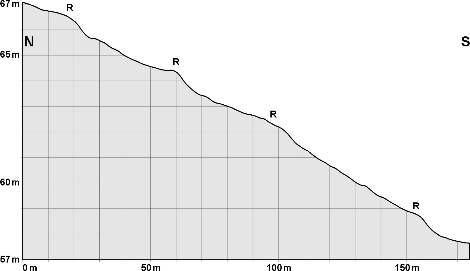
Zwei
Schnitte am Schachsel (oben: N-S, unten W-E), 10-fach
überhöht. Die Randwälle können am Nordhang bis zu 30 cm Höhe
erreichen. Two sections at the Schachsel (top: N-S, bottom W-E),
10 times exaggerated. The embankments can reach a height of up to 30
cm on the northern slope. |
 |
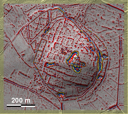
Der Schachsel ist eine mit 'Celtic Fields' bedeckte Anhöhe nördlich von
Westerkappeln dicht am Mittellandkanal und der Grenze zu Niedersachsen. Trotz
zahlreicher störender Eingrabungen sind die Randwälle, meistens Terrassenstufen,
gut ausgeprägt. Ein neuerer Ausgrabungsversuch, der zur Klärung des
Laserbefundes stattfand, darf als auf der ganzen Linie misslungen bezeichnet
werden (siehe
Blog des Landschaftsverbandes Westfalen-Lippe): anscheinend hat man dort an
Sieben nicht gedacht... The Schachsel is a knoll covered with 'Celtic Fields'
north of Westerkappeln close to the Mittelland Canal and the border with Lower
Saxony. Despite numerous disturbing diggings, the embankments, mostly terraced
steps, are well pronounced. A more recent excavation attempt, which took place
to clarify the laser findings, can be described as a complete failure (see the
blog of the Landschaftsverband Westfalen-Lippe): apparently they didn't
think of sieving...
Weiter more...
Daten www.geoportal.nrw. Wenn Sie
diese Grafik herunterladen, müssen Sie zur Georeferenzierung mit Global Mapper
oder Mapinfo auch das
TAB-File laden
und stets im gleichen Verzeichnis speichern. (Rechte Maustaste; Ziel speichern
unter... Bei Umbenennung darauf achten, dass auch innerhalb des Tab-Files der
Dateiname entsprechend umbenannt wird!) Data © www.geoportal.nrw. If you
download this graphic, you must also load the
TAB-File for
georeferencing with Global Mapper or Mapinfo and save it always in the same
directory. (Right mouse button; save target as... When renaming, make sure that
the file name is also renamed within the tab file accordingly).
Grafik georeferenziert als
GEOTIFF
herunterladen z.B. für Avenza Maps + Smartphone oder als
KMZ-File für
Benutzung mit Locus Map + Smartphone oder Google Earth. Download
georeferenced graphics as
GEOTIFF
e.g. for Avenza Maps + Smartphone or as
KMZ-File for
use with Locus Map + Smartphone or Google Earth.
Zurück Back
Übersicht Nordrhein-Westfalen Overview
North Rhine-Westphalia ©
Volker Arnold 2024