'Celtic Fields' – Stiefkinder der
Archäologie Archaeology's stepchildren
Spuren urgeschichtlicher Beackerung in West-,
Mittel-, Ost- und Nordeuropa Traces of prehistoric farming in Western,
Central, Eastern and Northern Europe: Ravnborg Skov, Nordjütland
Weiter more...
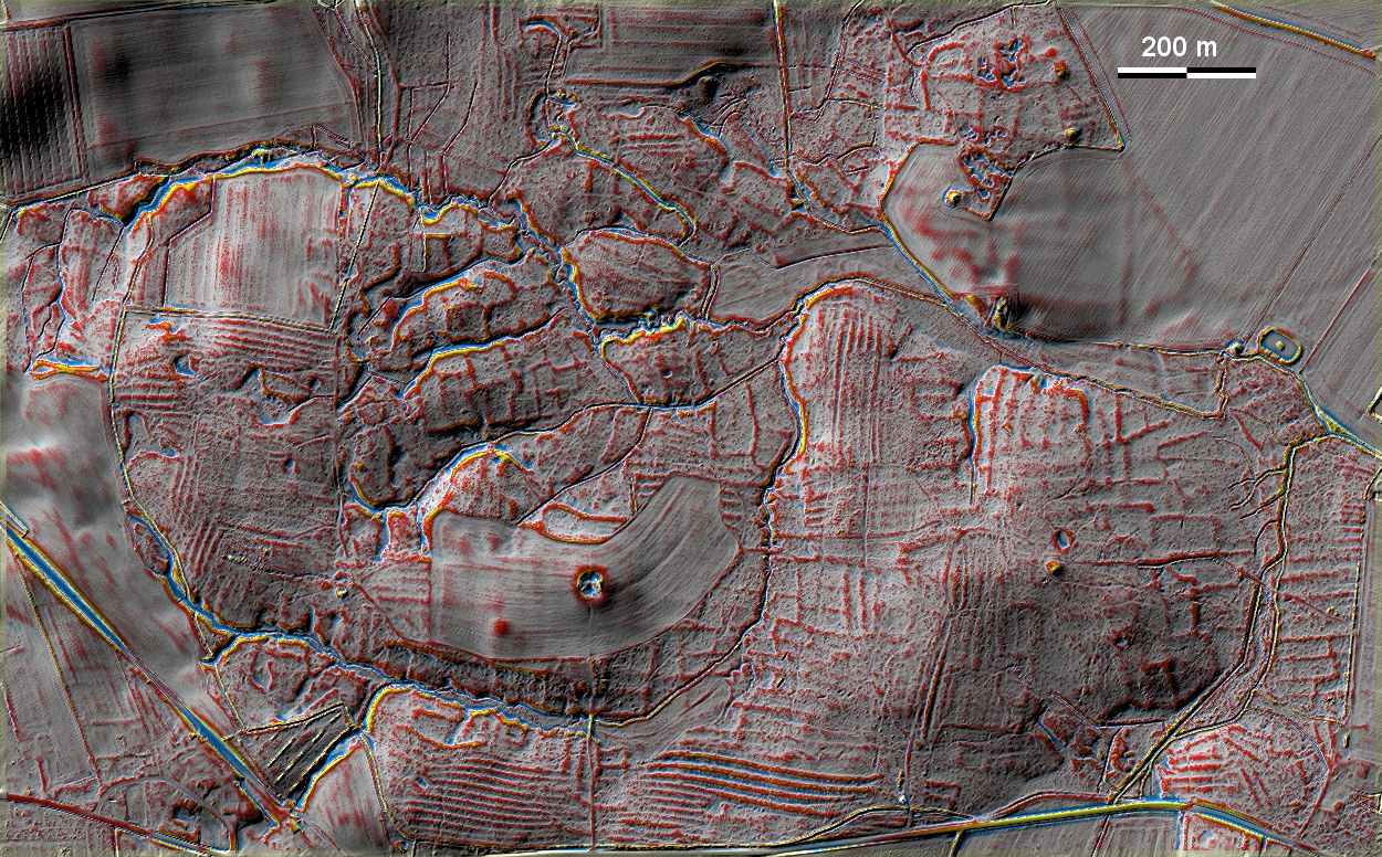
Im Ravnborg Skov südöstlich von Aalborg liegen auf einer Höhe über dem Lille
Vildmose sowohl gut ausgeprägte 'Celtic Fields' als auch Wölbbeete, außerdem
einige Grabhügel. Es ist keine Stelle erkennbar, wo 'Celtic-Fields'-Parzellen
durch Wölbbeete zerstört wurden; man hat eher den Eindruck, dass die Wölbbeete
die älteren Felder berücksichtigten. In Ravnborg Skov, southeast of Aalborg,
there are both well-developed Celtic Fields and ridge-and-furrow beds, as well
as some burial mounds, at a height above the Lille Vildmose. There is no
evidence of 'Celtic Fields' plots being destroyed by ridge-and-furrow beds;
rather, the impression is that the ridge-and-furrow beds took account of the
older fields. Weiter more...
Daten © sdfi.dk. Wenn Sie diese Grafik herunterladen, müssen Sie zur Georeferenzierung mit Global
Mapper oder Mapinfo auch das TAB-File
laden und stets im gleichen Verzeichnis speichern. (Rechte Maustaste; Ziel
speichern unter... Bei Umbenennung darauf achten,
dass auch innerhalb des Tab-Files der Dateiname entsprechend umbenannt wird!)
If you download this graphic, you must also load the TAB-File
for georeferencing with Global Mapper or Mapinfo and save it always in
the same directory. (Right mouse button; save target as... When renaming, make
sure that the file name is also renamed within the tab file accordingly).
Grafik georeferenziert als GEOTIFF herunterladen oder als
KMZ-File für Benutzung
mit Locus Map + Smartphone oder Google Earth. Download georeferenced graphics
as GEOTIFF e.g. for Avenza Maps + Smartphone or as
KMZ-File for use with Locus
Map + Smartphone or Google Earth.
Zurück
Back Übersicht Nordjütland Overview Jutland-North © Volker Arnold 2022