Spuren urgeschichtlicher Beackerung in West-, Mittel-, Ost- und Nordeuropa Traces of prehistoric farming in Western, Central, Eastern and Northern Europe: Schleberoda-West-Neue Göhle, Sachsen-Anhalt Saxony-Anhalt Weiter more...
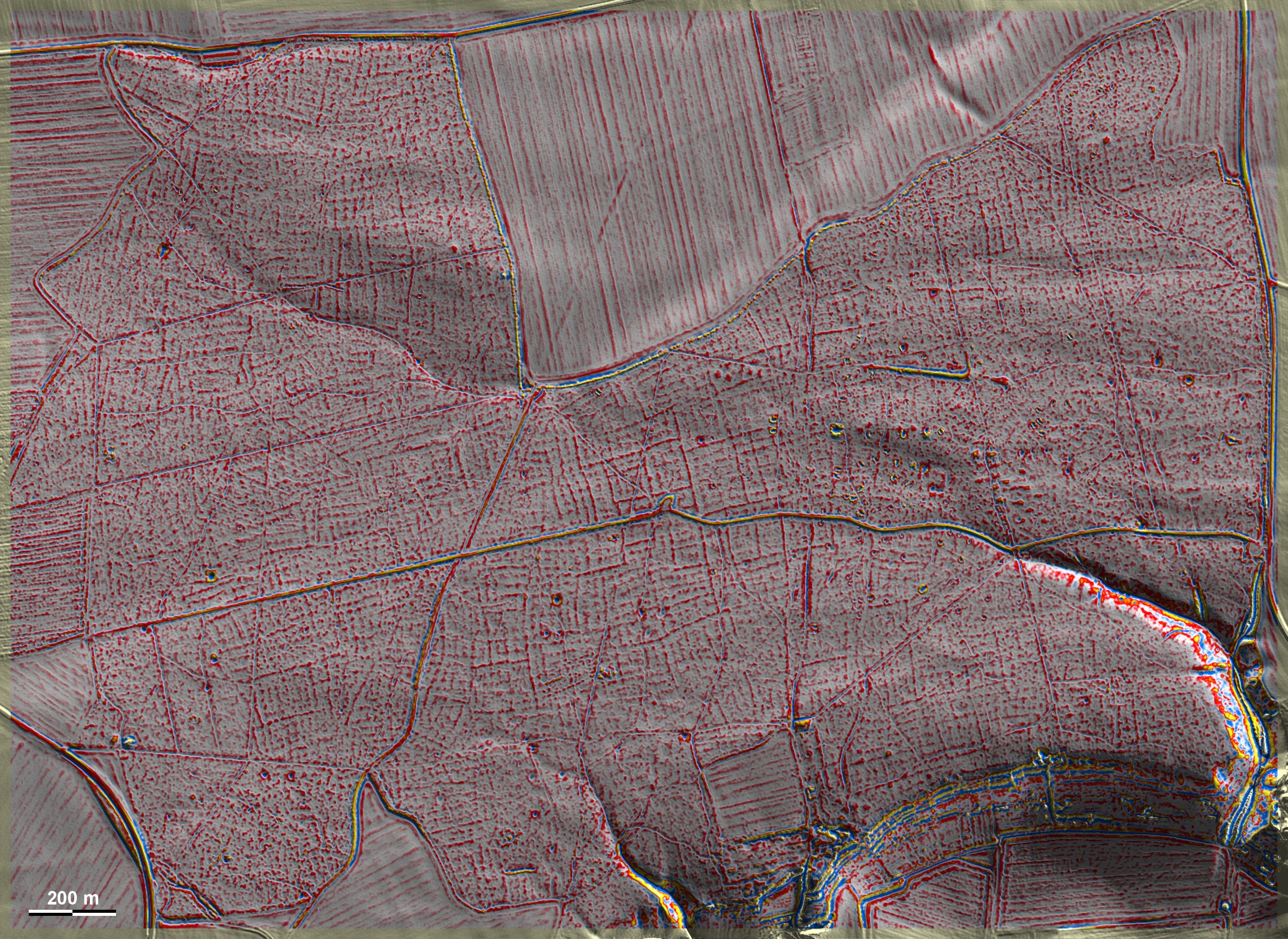
Die Neue Göhle, ein alter Waldstandort westlich von Schleberoda, liegt auf Freyberger Stadtgebiet. Hier finden sich die ausgedehntesten 'Celtic Fields' des Typs Przemęt in Sachsen-Anhalt, wenn auch nur in Bildmitte in optimaler Ausprägung. Über große Teile der Grafik erkennt man deutlich die etwas kräftigeren Randwälle übergeordneter Parzellen wie auch die sekundären (?) Unterteilungen in Quadrate von ca. 25 m Kantenlänge, in gleicher Ausrichtung wie das nur 6 km entfernte Mücheln-SW. Da es sich um einen Landesforst handelt, sollten minimalinvasive Sondagen hier keine allzu großen Probleme bereiten. Sollte ich herausstellen, dass auch hier die Felder unter Verwendung von Stall- und Hausabfällen (wie im Norden und Nordwesten üblich) gedüngt wurden oder andererseits eine Brandrodung der Bewirtschaftung voranging, sollten Datierungen über Holzkohlen oder ggf. sogar Tonscherben möglich sein. Alternativ könnten über OSL-Daten die letzte Belichtung des Sediments und damit die Beackerungszeit datiert werden. – Von Interesse ist eine Gruppe von länglichen Grabhügeln (?) östlich der Bildmitte, die an bestimmte trichterbecherzeitliche kujawische Gräber Polens erinnert. The Neue Göhle, an ancient forest site to the west of Schleberoda, is located on the Freyberg municipal territory. The most extensive 'Celtic Fields' of the Przemęt type in Saxony-Anhalt can be found here, albeit only in the centre of the image in optimal expression. Over large parts of the graphic, the somewhat stronger edge walls of superordinate plots as well as the secondary (?) subdivisions into squares of approx. 25 m edge length are clearly visible, in the same orientation as Mücheln-SW, which is only 6 km away. As this is a state forest, minimally invasive sondages should not cause too many problems here. If it turns out that the fields here were also fertilised using stable and household waste (as is common in the north and north-west) or, on the other hand, that slash-and-burn agriculture preceded the cultivation, dating should be possible using charcoal or possibly even pottery sherds. Alternatively, OSL data could be used to date the last exposure of the sediment and thus the time of cultivation. – Of interest is a group of elongated burial mounds (?) to the east of the centre of the picture, which are comparable to certain Funnel Beaker period Kuyavian barrows in Poland. Weiter more...


