'Celtic Fields' – Stiefkinder der
Archäologie Archaeology's stepchildren
Spuren urgeschichtlicher Beackerung in West-,
Mittel-, Ost- und Nordeuropa Traces of prehistoric farming in Western,
Central, Eastern and Northern Europe: Bischofsheim-Klaubholz, Bayern-Nord Bavaria-North
Weiter more...
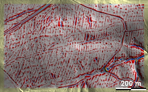
Die Beackerungsspuren im Klaubholz bei Bischofsheim in den Haßbergen sind hier
als Beispiel für eine Langstreifenflur aufgeführt, deren Anlage offenbar von
einem Locator "am grünen Tisch" ohne Rücksicht auf das Landschaftsrelief geplant
wurde. Die starke Ähnlichkeit mit entsprechenden Spuren in Brandenburg, der
Lausitz und großen Teilen des mittleren und südlichen Polens deuten an, dass sie
hier Zeugnisse frühmittelalterlicher slawischer Landnahme sein dürften. The
tillage traces in the Klaubholz near Bischofsheim in the Haßberge are listed
here as an example of long strip fields whose layout was apparently planned ba a
locator "in an ivory tower" without consideration of the landscape relief. The
strong similarity with corresponding traces in Brandenburg, Lusatia and large
parts of central and southern Poland indicate that they are likely to be
evidence of early medieval Slavic land take here. Weiter
more...
Daten © BVV/geodaten.bayern.de. Wenn Sie
diese Grafik herunterladen, müssen Sie zur Georeferenzierung mit Global Mapper
oder Mapinfo auch das
TAB-File laden
und stets im gleichen Verzeichnis speichern. (Rechte Maustaste; Ziel speichern
unter... Bei Umbenennung darauf achten, dass auch innerhalb des Tab-Files der
Dateiname entsprechend umbenannt wird!) Data © BVV/geodaten.bayern.de. If you
download this graphic, you must also load the
TAB-File for
georeferencing with Global Mapper or Mapinfo and save it always in the same
directory. (Right mouse button; save target as... When renaming, make sure that
the file name is also renamed within the tab file accordingly).
Grafik georeferenziert als
GEOTIFF
herunterladen z.B. für Avenza Maps + Smartphone oder als
KMZ-File für
Benutzung mit Locus Map + Smartphone oder Google Earth. Download
georeferenced graphics as
GEOTIFF
e.g. for Avenza Maps + Smartphone or as
KMZ-File for
use with Locus Map + Smartphone or Google Earth.
Zurück Back
Übersicht Bayern-Nord Overview Bavaria-North
Übersicht Bayern Overview Bavaria ©
Volker Arnold 2022