'Celtic Fields' – Stiefkinder der
Archäologie Archaeology's stepchildren
Spuren urgeschichtlicher Beackerung in West-,
Mittel-, Ost- und Nordeuropa Traces of prehistoric farming in Western,
Central, Eastern and Northern Europe: Schwarzach-Vorderes Holz, Bayern-Nord Bavaria-North
Weiter more...
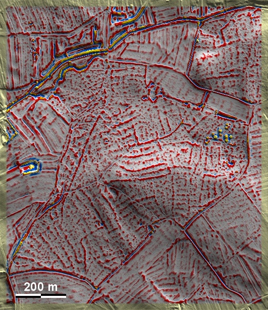
Das Vordere Holz auf einer sandig-kiesigen Pleistozän-Mainterrasse nördlich von
Schwarzach ist voller gut ausgeprägter 'Celtic Fields'. Sie lassen Spuren von
übergeordneten Parzellen sowie eine sekundäre Unterteilung in Langfelder
erkennen. Teilweise deutet sich eine Kammerung an, was für das Umfeld des Typs
Przemęt spricht. Die Grabhügelgruppe im Osten enthält Bestattungen der
Hallstattzeit. The Vordere Holz on a sandy-gravelly Pleistocene Main Terrace
north of Schwarzach is full of well-developed 'Celtic Fields'. They show traces
of superior plots as well as a secondary subdivision into long fields. In parts,
there is a hint of chambering, which speaks for the Przemęt type environment.
The mound group in the east contains burials of the Hallstatt period.
Weiter
more...
|
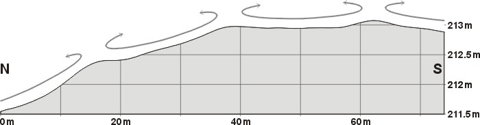 |
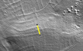
Schnitt N-S durch zwei
Parzellen und Lage des Schnitts
Section W-E through two
plots and location of the section |
 |
Daten © BVV/geodaten.bayern.de. Wenn Sie
diese Grafik herunterladen, müssen Sie zur Georeferenzierung mit Global Mapper
oder Mapinfo auch das
TAB-File laden
und stets im gleichen Verzeichnis speichern. (Rechte Maustaste; Ziel speichern
unter... Bei Umbenennung darauf achten, dass auch innerhalb des Tab-Files der
Dateiname entsprechend umbenannt wird!) Data © BVV/geodaten.bayern.de. If you
download this graphic, you must also load the
TAB-File for
georeferencing with Global Mapper or Mapinfo and save it always in the same
directory. (Right mouse button; save target as... When renaming, make sure that
the file name is also renamed within the tab file accordingly).
Grafik georeferenziert als
GEOTIFF
herunterladen z.B. für Avenza Maps + Smartphone oder als
KMZ-File für
Benutzung mit Locus Map + Smartphone oder Google Earth. Download
georeferenced graphics as
GEOTIFF
e.g. for Avenza Maps + Smartphone or as
KMZ-File for
use with Locus Map + Smartphone or Google Earth.
Zurück Back
Übersicht Bayern-Nord Overview Bavaria-North
Übersicht Bayern Overview Bavaria ©
Volker Arnold 2022