|
|
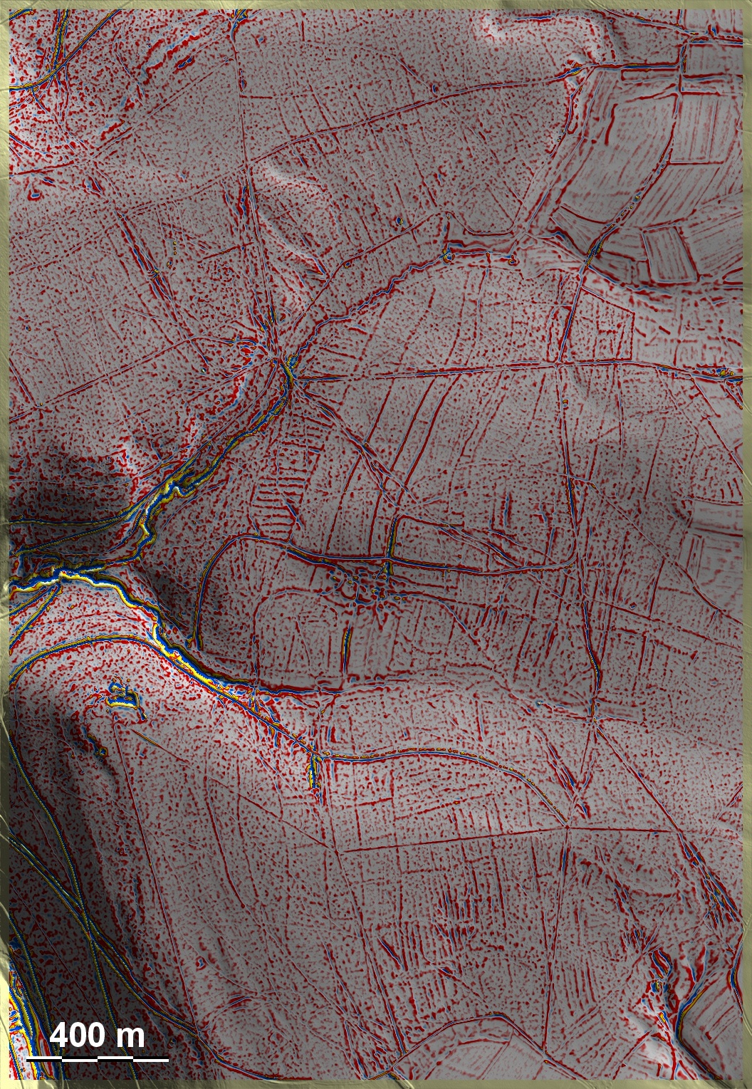
Detailansicht der Wüstung
Nappenbach im Reliefmodus
|
'Celtic Fields' – Stiefkinder der
Archäologie Archaeology's stepchildren
Spuren urgeschichtlicher Beackerung in West-,
Mittel-, Ost- und Nordeuropa Traces of prehistoric farming in Western,
Central, Eastern and Northern Europe: Wartmannsroth-Leiten, Bayern-Nord Bavaria-North
Weiter more...
|
|
Detailansicht der Wüstung
Nappenbach im Reliefmodus
|
Im Waldareal Leiten westlich Wartmannsroth am Südostabhang der Rhön finden sich im Wald auf Lehm- und Lössboden über Buntsandstein zahlreiche Beackerungsspuren. Ziemlich genau in Bildmitte sind Spuren der Dorfwüstung Nappenbach (1441 als wüst bezeugt) an Unregelmäßigkeiten im Relief erkennbar. Vielleicht gehören auch die hier erkennbaren Beackerungsspuren in das Hoch- und beginnende Spätmittelalter, zudem sie wegen ihrer abseitigen Lage und der ungewöhnlich lang durchlaufenden Parzellengrenzen von den üblichen Systemen abweichen. In the Leiten forest area west of Wartmannsroth on the south-eastern slope of the Rhön, numerous traces of cultivation can be found in the forest on loam and loess soil above sandstone. Traces of the deserted village of Nappenbach (attested as deserted in 1441) are recognisable from irregularities in the relief almost exactly in the centre of the picture. Perhaps the traces of cultivation visible here also belong to the High and Early Late Middle Ages, as they deviate from the usual systems due to their remote location and the unusually long parcel boundaries. Weiter more...
Daten © BVV/geodaten.bayern.de. Wenn Sie
diese Grafik herunterladen, müssen Sie zur Georeferenzierung mit Global Mapper
oder Mapinfo auch das
TAB-File laden
und stets im gleichen Verzeichnis speichern. (Rechte Maustaste; Ziel speichern
unter... Bei Umbenennung darauf achten, dass auch innerhalb des Tab-Files der
Dateiname entsprechend umbenannt wird!) Data © BVV/geodaten.bayern.de. If you
download this graphic, you must also load the
TAB-File for
georeferencing with Global Mapper or Mapinfo and save it always in the same
directory. (Right mouse button; save target as... When renaming, make sure that
the file name is also renamed within the tab file accordingly).
Grafik georeferenziert als
GEOTIFF
herunterladen z.B. für Avenza Maps + Smartphone oder als
KMZ-File für
Benutzung mit Locus Map + Smartphone oder Google Earth. Download
georeferenced graphics as
GEOTIFF
e.g. for Avenza Maps + Smartphone or as
KMZ-File for
use with Locus Map + Smartphone or Google Earth.
Zurück Back Übersicht Bayern-Nord Overview Bavaria-North Übersicht Bayern Overview Bavaria © Volker Arnold 2022