Spuren urgeschichtlicher Beackerung in West-, Mittel-, Ost- und Nordeuropa Traces of prehistoric farming in Western, Central, Eastern and Northern Europe: Staufersbuch-Högelberg, Bayern-Ost Bavaria-East Weiter more...
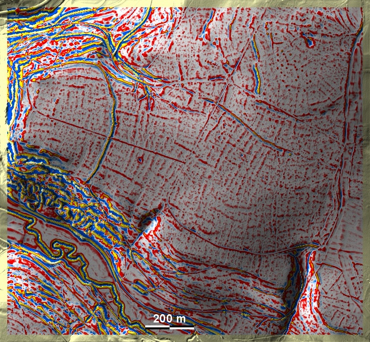
Auf dem Högelberg bei Staufersbuch fällt ein gut erhaltener Abschnittswall auf, der einen von der Unterbürger Laber umflossenen Sporn von der Jurahochfläche abtrennt. Fast die gesamte bewaldete Hochfläche ist durchzogen von schwach ausgeprägten 'Celtic Fields', die in das Umfeld des Typs Przemęt zu rechnen sind, wie Raine übergeordneter Parzellen und sekundäre Unterteilung nahelegen. Da die Feldspuren innerhalb und außerhalb des Abschnittswalls die gleiche Ausrichtung haben, ist anzunehmen, dass der Wall jünger als die Felder ist. Zwar gibt es innerhalb des Walls Funde der Bronzezeit, der Urnenfelder- und der Latènezeit, doch dadurch allein ist die Befestigung nicht datiert. Werner Robl hält den gesamten Abschnittswall für frühneuzeitlich – das möchte ich bezweifeln, halte aber eine Wiederverwendung in den frühneuzeitlichen kriegerischen Auseinandersetzungen für möglich. – Im Nordosten eine Gruppe sehr kleiner Grabhügel, die in dieser Grafik kaum erkennbar sind. On the Högelberg near Staufersbuch, a well-preserved sectional enclosure wall stands out, separating a spur flowed around by the Unterbürger Laber from the Jura plateau. Almost the entire forested plateau is interspersed with weakly developed 'Celtic Fields', which are to be counted in the environment of the Przemęt type, as suggested by rims of superior plots and secondary subdivisions. Since the field traces inside and outside the section enclosure have the same orientation, it can be assumed that the enclosure is younger than the fields. Although there are Bronze Age, Urnfield and Latène finds within the rampart, this alone does not date the fortification. Werner Robl considers the entire section rampart to be early modern – I doubt this, but I think it could have been reused in early modern warfare. – In the north-east, a group of very small tumuli, which are hardly recognisable in this graphic. Weiter more...