'Celtic Fields' – Stiefkinder der
Archäologie Archaeology's stepchildren
Spuren urgeschichtlicher Beackerung in West-,
Mittel-, Ost- und Nordeuropa Traces of prehistoric farming in Western,
Central, Eastern and Northern Europe: Fürstenfeldbruck-West / Aich-Ziegelhütte, Bayern-Süd Bavaria-South
Weiter more...
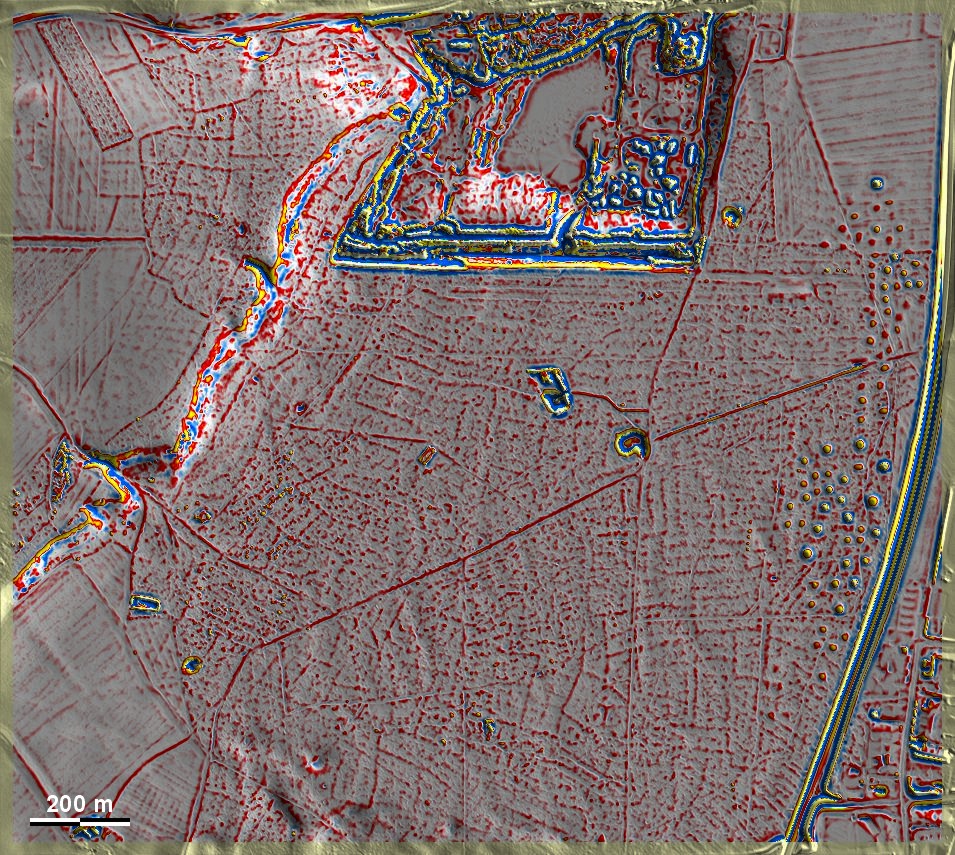
Im Rothschwaiger Forst auf den Amperschottern westlich von Fürstenfeldbruck
sowie auf der westlich anschließenden Moränenhöhe im Gehag bei Aich-Ziegelhütte
liegen 'Celtic Fields', die aber in vielen Bereichen vor allem auf den Amperschottern
uneinheitlich ausgerichtet und stark gestört erscheinen. Auf der Moränenhöhe
sind sie fragmentiert, aber klarer ausgeprägt, sogar im anschließenden Grünland.
Ein Datierungsindiz könnte die große hallstattzeitliche Grabhügelgruppe am
Ostrand der Grafik geben. Leider wird ein breiter Streifen südlich der
erkennbaren Kiesgrube demnächst dem Kiesabbau zum Opfer fallen. In the
Rothschwaiger Forst on the Amper gravel plain west of Fürstenfeldbruck as well
as on the adjacent moraine elevation in the Gehag near Aich-Ziegelhütte to the
west, there are 'Celtic Fields', but in many areas, especially of the gravel
plain, they appear inconsistently aligned and heavily disturbed. On the moraine
elevation they are fragmented but better pronounced, even in the adjacent
grassland. A dating indication could be given by the large Hallstatt barrow
group on the eastern edge of the diagram. Unfortunately, a wide strip south of
the recognisable gravel pit will soon fall victim to gravel extraction.
Weiter
more...
|
 |
 |
|
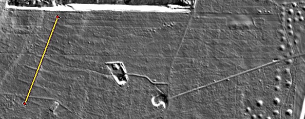
Schnitt Nord-Süd durch sieben
Parzellenraine (und einen heutigen Forstweg). Es wird deutlich, dass
die Wälle bei ca. 10 m Breite deutlich unter 20 cm Höhe bleiben.
Section north-south through seven plot boundaries (and a
present-day forest track). It can be seen that the embankments, at a
width of approx. 10 metres, remain well below 20 cm in height.
Lage des Schnittes Postition of section
|
Daten ©
BVV/geodaten.bayern.de. Wenn Sie
diese Grafik herunterladen, müssen Sie zur Georeferenzierung mit Global Mapper
oder Mapinfo auch das
TAB-File laden
und stets im gleichen Verzeichnis speichern. (Rechte Maustaste; Ziel speichern
unter... Bei Umbenennung darauf achten, dass auch innerhalb des Tab-Files der
Dateiname entsprechend umbenannt wird!) Data © BVV/geodaten.bayern.de. If you
download this graphic, you must also load the
TAB-File for
georeferencing with Global Mapper or Mapinfo and save it always in the same
directory. (Right mouse button; save target as... When renaming, make sure that
the file name is also renamed within the tab file accordingly).
Grafik georeferenziert als
GEOTIFF
herunterladen z.B. für Avenza Maps + Smartphone oder als
KMZ-File für
Benutzung mit Locus Map + Smartphone oder Google Earth. Download
georeferenced graphics as
GEOTIFF
e.g. for Avenza Maps + Smartphone or as
KMZ-File for
use with Locus Map + Smartphone or Google Earth.
Zurück Back
Übersicht Bayern-Süd Overview Bavaria-South
Übersicht Bayern Overview Bavaria ©
Volker Arnold 2023