'Celtic Fields' – Stiefkinder der
Archäologie Archaeology's stepchildren
Spuren urgeschichtlicher Beackerung in West-,
Mittel-, Ost- und Nordeuropa Traces of prehistoric farming in Western,
Central, Eastern and Northern Europe: Münsing-Nordwest-Herrenholz, Bayern-Süd Bavaria-South
Weiter more...
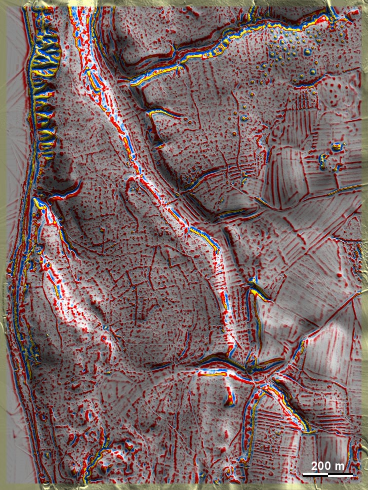
Das Herrenholz nordwestlich von Münsing liegt auf der Jungmoräne ca. 30
Höhenmeter über dem Starnberger See und beherbergt teilweise gut ausgeprägte
'Celtic Fields', die entsprechend dem stark reliefierten Untergrund unregelmäßig
ausfallen. Nordöstlich schließt eine umfangreiche Gruppe hallstattzeitlicher
Grabhügel an – ein Datierungsindiz? Herrenholz, northwest of Münsing, is
situated on a young moraine about 30 metres above Lake Starnberg and contains
partly pronounced 'Celtic Fields', which are irregular in shape due to the
relief of the subsoil. To the north-east, there is an extensive group of
Hallstatt burial mounds – an indication of dating? Weiter
more...
|
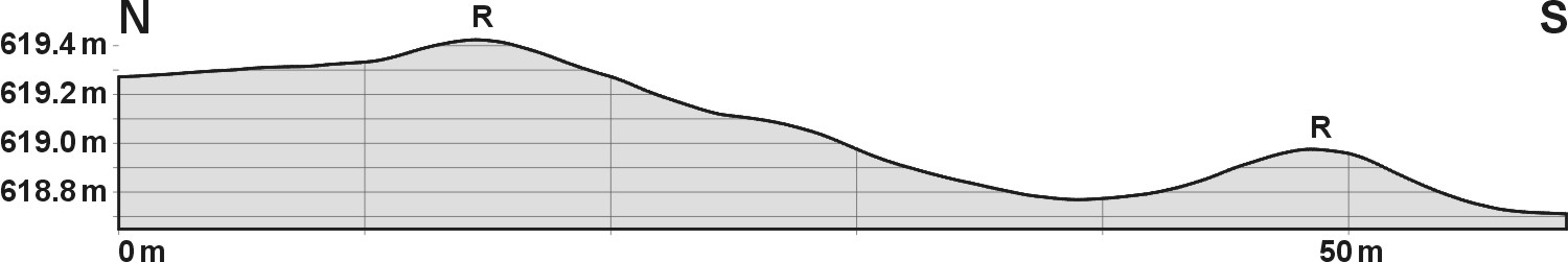
Schnitt durch eine schmale Parzelle, 10-fach
überhöht, und Lage des
Schnitts. Hier erreicht der südliche Grenzwall der Parzelle
tatsächlich einmal 20 cm Höhe, bei ca. 10 m Breite. R:
Parzellenränder
Section through a narrow plot, 10 times
exaggerated, and location of
the section. Here, the southern boundary wall of the plot actually
reaches a height of 20 cm, with a width of approx. 10 m. R: Plot
edges |
 |
Daten © BVV/geodaten.bayern.de. Wenn Sie
diese Grafik herunterladen, müssen Sie zur Georeferenzierung mit Global Mapper
oder Mapinfo auch das
TAB-File laden
und stets im gleichen Verzeichnis speichern. (Rechte Maustaste; Ziel speichern
unter... Bei Umbenennung darauf achten, dass auch innerhalb des Tab-Files der
Dateiname entsprechend umbenannt wird!) Data © BVV/geodaten.bayern.de. If you
download this graphic, you must also load the
TAB-File for
georeferencing with Global Mapper or Mapinfo and save it always in the same
directory. (Right mouse button; save target as... When renaming, make sure that
the file name is also renamed within the tab file accordingly).
Grafik georeferenziert als
GEOTIFF
herunterladen z.B. für Avenza Maps + Smartphone oder als
KMZ-File für
Benutzung mit Locus Map + Smartphone oder Google Earth. Download
georeferenced graphics as
GEOTIFF
e.g. for Avenza Maps + Smartphone or as
KMZ-File for
use with Locus Map + Smartphone or Google Earth.
Zurück Back
Übersicht Bayern-Süd Overview Bavaria-South
Übersicht Bayern Overview Bavaria ©
Volker Arnold 2023