'Celtic Fields' – Stiefkinder der
Archäologie Archaeology's stepchildren
Spuren urgeschichtlicher Beackerung in West-,
Mittel-, Ost- und Nordeuropa Traces of prehistoric farming in Western,
Central, Eastern and Northern Europe: Kemmathen-Fuchsknock-Süd, Bayern-Nord Bavaria-North
Weiter more...
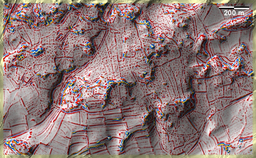
Um den Fuchsknock bei Kemmathen in der Oberpfälzer Alb ist die Jurahochfläche
von vielen felsigen Aufragungen durchsetzt. 'Celtic Fields' finden sich in den
flacheren Partien zwischen den Aufragungen auf lehmigen und schluffigen Böden,
überwiegend aber auf Kalkrohböden. Geländebedingt lassen sie sich keinem
dezidierten Typ zuordnen. Etwas östlich der Bildmitte eine Streuung von (hier
schwer erkennbaren) Grabhügeln. Around the Fuchsknock near Kemmathen in the
Upper Palatinate Alb, the Jura plateau is interspersed with many rocky outcrops.
Celtic Fields' are found in the flatter parts between the outcrops on loamy and
silty soils, but predominantly on limestone raw soils. Due to the terrain, they
cannot be assigned to a specific type. A little to the east of the centre of the
picture, a scatter of burial mounds (difficult to recognise here).
Weiter more...
Daten © BVV/geodaten.bayern.de. Wenn Sie
diese Grafik herunterladen, müssen Sie zur Georeferenzierung mit Global Mapper
oder Mapinfo auch das
TAB-File laden
und stets im gleichen Verzeichnis speichern. (Rechte Maustaste; Ziel speichern
unter... Bei Umbenennung darauf achten, dass auch innerhalb des Tab-Files der
Dateiname entsprechend umbenannt wird!) Data © BVV/geodaten.bayern.de. If you
download this graphic, you must also load the
TAB-File for
georeferencing with Global Mapper or Mapinfo and save it always in the same
directory. (Right mouse button; save target as... When renaming, make sure that
the file name is also renamed within the tab file accordingly).
Grafik georeferenziert als
GEOTIFF
herunterladen z.B. für Avenza Maps + Smartphone oder als
KMZ-File für
Benutzung mit Locus Map + Smartphone oder Google Earth. Download
georeferenced graphics as
GEOTIFF
e.g. for Avenza Maps + Smartphone or as
KMZ-File for
use with Locus Map + Smartphone or Google Earth.
Zurück Back
Übersicht Bayern-Nord Overview Bavaria-North
Übersicht Bayern Overview Bavaria ©
Volker Arnold 2022