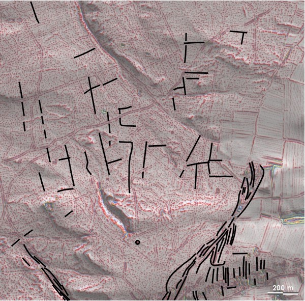
Spuren urgeschichtlicher Beackerung in West-, Mittel-, Ost- und Nordeuropa Traces of prehistoric farming in Western, Central, Eastern and Northern Europe: Geisenfeld-Feilenforst-Hirschensprung, Bayern-Süd Bavaria-South Weiter more...
Um den "Hirschensprung" im Feilenforst bei Geisenfeld liegen ganz schwach ausgeprägte 'Celtic Fields', die hier nur deswegen Aufnahme finden, weil sie nur 8 km von der berühmten Keltenstadt von Manching entfernt liegen. Es handelt sich um Fragmente größerer Parzellen, die in Bildmitte etwa parallel zu den Haupthimmelsrichtungen liegen, westlich davon aber etwas in Westrichtung gedreht sind. (Ähnliches findet man auch am Nordwestrand des Feilenforstes, noch dichter an Manching, dort mit einer hallstattzeitlichen Grabhügelgruppe zusammen gelegen.) Die tertiären Molasseböden sind sandig bis lehmig, teils mit Flugsandauflage und Dünenbildung. Mindestens ein Grabhügel (südlich der Bildmitte). Around the "Hirschensprung" in the Feilenforst near Geisenfeld are very faintly pronounced 'Celtic Fields', which are only included here because they are just 8 kilometres from the famous Celtic town of Manching. These are fragments of larger plots of land that lie roughly parallel to the main cardinal directions in the picture centre, but are turned slightly anti-clockwise to the west. (Similar features can also be found on the north-western edge of the Feilenforst, even closer to Manching, where they are located together with a group of Hallstatt burial mounds.) The Tertiary molasse soils are sandy to loamy, partly with a covering of drifting sand and dune formation. At least one burial mound (south of the image centre). Weiter more...