Traces of prehistoric farming in Western, Central, Eastern and Northern Europe: maps
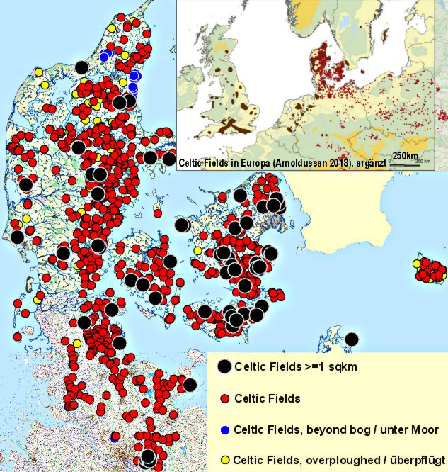
Celtic Fields in Denmark and Schleswig-Holstein after LIDAR data (without dubious records). Please click into areas of the map to get detail maps!
'Celtic Fields' – Archaeology's stepchildren
Traces of prehistoric farming in Western,
Central, Eastern and Northern Europe:
maps
Celtic Fields in Denmark and Schleswig-Holstein after
LIDAR data (without dubious records). Please click into areas of the map to get
detail maps!
Or, click on subareas indicated in the list below to access georeferenced maps and further to specific Celtic Fields graphics:
SCHLESWIG-HOLSTEIN (still only in German):
Nordfriesland/Sylt/Amrum/Schleswigsche Geest
– Angeln/Schwansen –
Dithmarschen –
Mittelholstein/Kiel – Ostholstein –
Südholstein
DENMARK (islands still without texts):
South Jutland/Als (UTM-32U, Northing up to 6170000) –
West Jutland
(Easting from 500000, Northing 6170000-6280000) –
East Jutland-South (Easting
from
50000, Northing 6170000-6230000) –
East Jutland-North (Easting
from
50000, Northing 6230000-6280000) – North
Jutland
(Northing from 6280000) – Fyn/Langeland –
Lolland/Falster/Møn –
South Sealand
(Northing up to 6160000)
–
North-Sealand
from 6160000)
–
Bornholm
MECKLENBURG-VORPOMMERN –
New:
Nothrhine-Westphalia –
LOWER SAXONY: Landkreis
Stade –
New:
Poland
–
New:
Bavaria
– New: Hesse
– New:
Netherlands/Flanders –
New:
Brandenburg –
New:
Saxonia-Anhalt Back © Volker Arnold 2019